Day 169: Mount Jackson

15,69 km (9.7 miles)
1849.9 / 2189.8 miles
Stealth campsite, NH

The rain started in the morning when I was waking up. I was tempted to just stay in my tent and avoid the day in rain, but slowly my sense of duty exceeded my sense of comfort. There was miles to do.

Packing up the tent is a truly annoying process when it’s raining. I was trying to pour out the puddle that was forming on the tent, but it was all the time raining more. In the end I stood with the rolled tent between my thighs and succeeded to squeeze most of the water out of that green and yellow burrito.

I was wishing that I could be able to keep my shoes dry. That wishful thinking was about to die sooner rather than later. Even though my rain gear kept me relatively dry, the bushes on the trail side brushed my pants wet and that got my socks and eventually my shoes wet, too.

The beginning of the day’s trek was pretty flat and I would have been able to hike fast, but the rain had changed the AT into a chain of puddles. The descent to Crawford Notch was less steep and painless that I had expected, though. I had my lunch in the notch while it was not raining and continued to the uphill wishing that the rain was gone for good.

Once again, wishful thinking. When I had ascended the first part of the uphill with nice speed – and in the process got my clothes to dry a bit – the rain started again. It felt exhausting and frustrating to get wet again. And the uphill was getting steeper and rockier. Everything was somehow heavy and agonising. I was huffing and swearing.

I hadn’t got really any service on my phone for few days. I tried once again when I sat down for a while at a view, where there really was no view through the clouds. I got one bar and checked my Facebook. My brother and his wife had used the FB safety check to inform that they were safe during the attack in Turku. What attack in Turku? What is there happening in Finland? The bad connection didn’t allow me to load any news sites and my battery was dying. In my own Facebook I asked my friends to tell me what is happening in Turku, because this seemed be the only thing that was working over the weak service.

I continued my ascent to Mount Webster. There was more and more steep rock faces where I really had to climb. The rain had made everything slippery and climbing took a lot of effort. More huffing, puffing and swearing.

A bit later I was able to get some service again. My friends and brother had told on Facebook that a man had stabbed eight people in downtown Turku. Two of them were dead. It seemed not to be an act of terrorism, but no one really knew yet. The police had shot the man in leg and caught him.

These news from home were nothing to lift up the overall depressing mood of the day. I was sloshing towards Mount Jackson and started to look for a tent spot. I had seen several good spots close to Mount Webster and expected there to be more.

Well, I expected wrong. The forest was sloping, dense and against all sense also swampy at the same time. There was no way to fit a tent to this uneven tree filled wetland. The sun was setting and it was getting dark. I was wet and exhausted. I just wanted to get somewhere, anywhere to sleep. I crossed an alpine bog over the bog bridges and found an open flat site. I was joying that I finally found my tent site until I saw that someone had used this only flat and open spot as their latrine. I cursed this surface shitter to the lowest level of Dante’s inferno.

There was nothing else to do, but keep on looking. At some point I stopped to dig out my head torch. I really didn’t want to do second long day in a row, especially when tomorrow I had to get up early. I had the Presidential traverse ahead of me. This group of mountains is named after different presidents of United States and in the middle of it is Mount Washington. This almost 2000er (6000 footer) is known of its rapidly changing weather and extremely high winds. And most of this traverse should be done in one day.

Eventually I saw a small spot, just maybe large enough to fit my tent, right next to the trail. There was a pothole, rocks, roots and everything, but I had to try. I was horribly tired. I succeeded pitching my tent into that spot that was so uneven that it must have been the shittiest tent site of the whole thru-hike. I took off my soaking wet shoes and socks. The skin of my hands and feet was wrinkled by the wet conditions and it was tearing off in large sheets. I felt relieved to put on dry clothes. Still I was painfully aware that in the morning I would have to put those wet shoes back on. I laid me down on my mattress where I kept on sliding all the time to some direction. I would have rather been anywhere else.

“Još te ne dam maglama sa planina
Još te ne dam vodama iz dubina
A ti kažeš pusti me, živ mi bio
Zaboravu predaj me, sad adio”
-Knez
(Adio, 2015)

“I still don’t give you to the mists of the mountains
I still don’t give you to the depths of the water
And you ask me to let you go, forever
To sink you into oblivion and say goodbye”
-Knez
(Adio, 2015)

Total time: 02:08:57

Sade alkoi aamulla heräillessäni. Minua houkutteli jäädä vain lepäämään telttaani ja välttää sadepäivä, mutta pikkuhiljaa velvollisuudentuntoni voitti mukavuudenhaluni. Olisi maileja tehtävänä.

Teltan pakkaaminen oli ärsyttävää sateessa. Yritin kaadella muodostuvaa lätäkköä pois teltan päältä kasatessani sitä, mutta vettä ehti sataa aina lisää. Lopulta puristin reisieni välissä rullattua telttaani onnistuen valuttamaan tuosta vihreänkeltaisesta burritosta melkoisen määrän vettä.

Elättelin toiveita siitä, että kenkäni säilyisivät kuivana. Ne toiveet eivät kuitenkaan eläneet pitkään. Vaikka sadevarusteet pitivät minut muuten melko kuivana, kastuivat housujen lahkeet ympäröivästä pusikosta ja sitä myötä sukat ja kengät.

Alkumatka oli melko tasaista ja polku olisi ollut nopeakulkuista ellei sade olisi muuttanut AT:a ketjuksi lätäköitä. Laskeutuminen Crawford Notchiin oli onneksi loivempi ja kivuttomampi kuin olin odottanut. Söin notkon pohjalla sateen hetkeksi tauotessa ja jatkoin ylämäkeen toivoen sateen jo kokonaan loppuneen.

Toiveajattelua. Noustuani reippaasti ylämäen alkuosan ja saatua samalla vaatteeni melko kuiviksi alkoi sade taas uudestaan. Tuntui väsyttävältä ja turhauttavalta kastua taas. Samalla nousu muuttui kokoajan jyrkemmäksi ja kivikkoisemmaksi. Kaikki oli jotenkin raskasta ja ahdistavaa. Puuskutin ja kiroilin.

Kännykässä ei ollut ollut kenttää pariin päivään. Kokeilin taas kerran istahtaessani hetkeksi näköalapaikalle, josta ei pilven läpi ollut minkäänlaista näköalaa. Onnistuin saamaan yhden tolpan kenttää ja vilkaisin Facebookia. Veljeni ja hänen vaimonsa olivat ilmoittaneet FB:n toiminnolla olevansa turvassa Turun hyökkäykseen liittyen. Mikä Turun hyökkäys? Mitä Suomessa on tapahtunut? Hatara yhteys ei jaksanut ladata uutissivuja ja akku hupeni silmissä. Pyysin omassa Facebookissani ystäviä kertomaan mitä Turussa tapahtuu, koska tämä väylä näytti toimivan heikolla yhteydellä parhaiten.

Jatkoin nousua kohti Mount Websteriä. Edessä oli jatkuvasti enemmän jyrkkiä kallioita, joissa sai todella kiivetä. Sateen vuoksi joka paikka oli liukas ja kulkeminen vaivalloista. Lisää puuskutusta, ähkimistä ja kiroilua.

Saadessani hieman myöhemmin taas hetkeksi kenttää kännykkään sain tietää ystävieni ja veljeni välityksellä, että Turussa oli joku mies puukottanut kahdeksaa ihmistä keskustassa. Kaksi oli kuollut. Ilmeisesti kyseessä ei ollut terrorismi, mutta asiasta ei ollut vielä kovin tarkkoja tietoja. Poliisi oli ampunut tekijää jalkaan ja saanut tämän kiinni.

Uutiset kotimaasta eivät mitenkään erityisesti nostaneet päivän masentavaa mielialaa. Rämmin kohti Mount Jacksonia ja aloin katsella mahdollista telttapaikkaa. Olin nähnyt useita hyviä paikkoja lähellä Mount Websteriä, joten ajattelin lisää olevan varmasti tarjolla.

No, ajattelin hyvin väärin. Metsä oli jatkuvasti mäkistä, tiivistä ja vastoin kaikkea järkeä myös samalla soista. Epätasaiseen kosteikkoryteikköön ei saisi telttaa minnekään. Aurinko laski ja alkoi hämärtää. Olin märkä ja uupunut. Halusin vain saada itseni jonnekin yöksi. Ylitin pitkospuita pienen suoalueen ja sen vierestä löytyi avoin paikka. Ehdin jo iloita telttapaikan löytymisestä, kunnes huomasin jonkun käyttäneen tätä ainoaa tasaista ja avointa kohtaa käymälänään. Kirosin tämän surface shitterin, pintapaskojan, alimpaan helvettiin.

Ei auttanut kuin jatkaa etsintöjä. Jossain vaiheessa pysähdyin kaivamaan repustani otsalampun nähdäkseni pimeässä. En olisi millään halunnut tehdä toista pitkään venyvää päivää putkeen, kun huomenna olisi mahdollisesti aikainen herätys. Edessä olisi niin kutsuttu Presidential traverse eli Presidential rangen poikkikulku. Tämä vuorijono koostuu Yhdysvaltain presidenttien mukaan nimetyistä vuorista ja sen keskellä on Mount Washington. Tuo hieman alle paritonninen vuori on kuuluisa vaihtelevasta säästä ja kovista tuulista. Ja suurin osa tästä poikkikulusta pitäisi yrittää tehdä yhdessä päivässä.

Lopulta näin polun vieressä pienen, ehkä juuri ja juuri telttani kokoisen aukon metsässä. Siinä oli kuoppaa, kiveä ja juurakkoa, mutta pakko oli yrittää. Olin hirveän väsynyt. Sain tungettua teltan koloon, joka epätasaisuudessaan oli varmasti koko reissun huonoin telttapaikka. Riisuin märät kengät ja sukat. Sekä kämmenten että jalkojen iho oli kosteudesta ruttuinen ja irtoili laajoina laattoina. Kuivat vaatteet olivat helpotus. Olin kuitenkin kivuliaan tietoinen, että aamulla pitäisi vetää taas märät kengät jalkaan. Kävin pitkälleni makuualustalle, jossa valuin kokoajan johonkin suuntaan ja olisin ollut mielummin missä tahansa muualla.

“Još te ne dam maglama sa planina
Još te ne dam vodama iz dubina
A ti kažeš pusti me, živ mi bio
Zaboravu predaj me, sad adio”
-Knez
(Adio, 2015)

“I still don’t give you to the mists of the mountains
I still don’t give you to the depths of the water
And you ask me to let you go, forever
To sink you into oblivion and say goodbye”
-Knez
(Adio, 2015)

Day 168: South Twin Mountain

17,39 km (10.8 miles)
1839.2 / 2189.8 miles
Stealth campsite, NH

The morning was chilly. It wasn’t cold in my sleeping bag, but when I got out of there the down coat was the most comfortable choice. I started hiking still wearing my down coat and a beanie, but quite soon the day and my body started to warm up and I was able to go on wearing a t-shirt.

I had decided to stop at the Galehead Hut to have the lunch soup and the AT seemed not to have any significant climbs before that. Well, there was no significant climbs, but small ups and downs all the time. Enough to slow me down more than I had expected.

I arrived to the hut a bit after noon and contently suffed my face with two bowls of potato dill soup. I have had a couple of visits to the hospital that had made any cream soup to taste repulsive, but this hodgepodge sunk in without complaints. My constant hunger might have had its effect and perhaps this soup was somewhat more tasty than the ones that they serve in a hospital.

In the White Mountains there is a network of these huts that are maintained by the Appalachian Mountain Club (AMC). AMC is also known by the nickname Appalachian Money Club, because staying in the hut is ridiculously expensive – more than hundred dollars a night. Even though this includes the dinner and the breakfast, I have paid a lot less staying in the huts in the Alps. Even in Switzerland that is known to be expensive. The AMC huts are not the choice for a budget traveller, but they do offer a possibility to do work-for-stay. As far as I know the WFS means couple hours of work and you get to sleep on the floor and eat the leftovers of dinner and breakfast. But to get a WFS you need to be at the hut quite early and that doesn’t fit my schedules, because I prefer to hike late. Anyway the huts do have something for me too, because they offer the cheap lunch soup, potable water and a privy.

From the hut started the steep uphill to South Twin Mountain. I was climbing slowly up the rocky slope to the windy summit. The descent was in the beginning as steep as the ascent had been, but slowly it changed to more gentle. I marched downhill towards the Zealand Falls Hut. I knew that there would be a few tent sites nearby. When I reached the hut it was coming dark and I put my head torch on.

Soon I found the first tent site, but it was already full. Well, I just continued on to the deepening dark. Also the next tent site was taken. I checked the Guthook app and learned that two miles further there would be more tent sites. There was nothing else to do than to keep on trucking to the darkness. Luckily the AT was very flat here and I was hiking fast. It was clear that I would not drop in on any unknown tent sites, because on the other side there was a rock face and on the other side a steep slope down.

I was tired and I just wanted to sleep. Finally I arrived close to the Thoreau Falls and found the tent spot that I had been looking for. It wasn’t especially spacious, but I was able to fit my tent there and relieved I sat inside. In the middle of the darkness my own little reality felt like a really lonely place.

“Joskus me eksytään yksin pimeään
Huudetaan kunnes itketään
Sanat on turhia eikä ne tuu riittämään
Annan mun rakkauden enkä pyydä mitään
En oo unohtanu sitä mitä sanoin
En oo luovuttanu siitä minkä vannoin
Ja jos sanoinkin sen ääneen liian harvoin,
Niin sua jatkuvasti mielessäni kannoin

Täällä mä oon, vieläkin sun
Nousen pystyyn jos kaadun
Haluun saada syttyyn sun soihdun
Sun hymystä mä voimaannun
Ja täällä mä oon niin kauan kun
viimeisen kerran kaadun
Jos sä haluut sotilaan mä varustaudun
Jos haluut rauhaa mä antaudun”
-Reino Nordin
(Antaudun, 2017)

“Sometimes we get lost alone in the dark
Screaming until we are crying
The words are useless and they won’t be enough
I give my love and I won’t ask for anything
I haven’t forgot what I said
I haven’t given up for what I vowed
And even if I said it out loud too seldom
I constantly carried you in my mind

Here I am, still yours
I get up if I fall
I want to light up your torch
I am empowered by your smile
And here I am as long until
I fall for the last time
If you want a soldier, I gear up
If you want peace, I surrender”
-Reino Nordin
(Antaudun, 2017)

Total time: 02:52:01

Aamu oli viileä. Minulla ei ollut kylmä makuupussissani, mutta sieltä ulos tultuani tuntui mukavimmalta vaihtoehtolta vetää untuvatakki päälle. Lähdin vaeltamaankin untuvatakissa ja pipossa, mutta hyvin pian sekä päivä että kehoni alkoi lämmetä, jonka jälkeen tarkenin taas hyvin t-paidassa.

Olin päättänyt pysähtyä Galehead Hutilla lounaskeitolla ja olin katsellut AT:n olevan sinne asti vailla suurempia korkeuseroja. No, suuria vaihteluita ei ollut, mutta pientä kapuamista koko ajan siinä määrin, etten edennyt ollenkaan niin nopeasti kuin olin ajatellut.

Tulin kuitenkin vähän puolenpäivän jälkeen majalle ja vedin hyvillä mielin kaksi lautasellista peruna-tilli -keittoa. Olen kehittänyt parin sairaalakokemuksen jälkeen vastenmielisyyden sosekeittoja kohtaan, mutta nyt tämä soossi upposi aivan ongelmitta. Nälkä oli ehkä osatekijänä ja ehkä keitossa oli myös enemmän makua kuin sairaalan sörsseleissä.

White Mountainsilla on siis AMC:n eli Appalachian Mountain Clubin ylläpitämä majaverkosto. Yhdistys on saanut myös pilkkanimen Appalachian Money Club, koska majojen yöpymishinnat ovat omastakin mielestäni aika kohtuuttomia – reilusti yli sata dollaria yö. Vaikka tähän sisältyykin illallinen ja aamiainen niin olen päässyt huomattavasti halvemmalla alppien majoilla. Jopa kalliissa Sveitsissä. AMC:n majat eivät siis ole ehkä budjettimatkailijan suosiossa, mutta ne kuitenkin tarjoavat läpivaeltajille work-for-stay -mahdollisuutta. WFS sisältää tietääkseni pari tuntia työtä majalla ja vastineeksi saa nukkua majan lattialla sekä syödä ilta- ja aamuruuan ylijäämät. Kuitenkin halutessan tehdä WFS:ta pitää majalla olla aikaisin ja siten se ei sovi omaan tapaani vaeltaa pitkään illalla. Mutta joka tapauksessa majat tarjoavat kaltaiselleni ohikulkijallekin tuota edullista lounaskeittoa sekä juomavettä ja mukavuuslaitoksen.

Majalta alkoi jyrkkä nousu South Twin Mountainille. Kiipesin hitaasti kallioista rinnettä tuuliselle huipulle. Laskeutuminen oli aluksi yhtä jyrkkää kuin nousukin, mutta lopulta rinne muuttui loivemmaksi. Marssin alamäkeä kohti Zealand Falls Hutia, jonka lähellä oli tiedossani parikin telttapaikkaa. Majalle saapuessani alkoi tulla hämärä, joten kaivoin otsalampun valmiiksi esiin.

Pian löysinkin telttapaikan, mutta siellä oli jo väkeä. No, jatkoin syvenevässä pimeässä kohti seuraavaa. Myös tämä paikka oli vallattu. Vilkaisin Guthook-sovellusta ja ainakin parin mailin päässä oli sen mukaan telttapaikka. Ei auttanut muu kuin painaa menemään läpi pimeyden. Onneksi AT oli todella tasainen ja etenin vauhdilla. Oli selvää, ettei mitään yllätystelttapaikkoja olisi tarjolla, koska toisella puolellani nousi kallioseinämä ja toisella puolella oli jyrkkä rinne alas.

Minua väsytti ja halusin vain päästä nukkumaan. Lopulta saavuin Thoreau Fallsin lähelle ja löysinkin etsimäni telttapaikan. Tilaa oli hieman niukasti, mutta sain telttani pystyyn ja helpottuneena istuin sen sisälle. Oma pieni todellisuuteni pimeän keskellä tuntui yksinäiseltä paikalta.

“Joskus me eksytään yksin pimeään
Huudetaan kunnes itketään
Sanat on turhia eikä ne tuu riittämään
Annan mun rakkauden enkä pyydä mitään
En oo unohtanu sitä mitä sanoin
En oo luovuttanu siitä minkä vannoin
Ja jos sanoinkin sen ääneen liian harvoin,
Niin sua jatkuvasti mielessäni kannoin

Täällä mä oon, vieläkin sun
Nousen pystyyn jos kaadun
Haluun saada syttyyn sun soihdun
Sun hymystä mä voimaannun
Ja täällä mä oon niin kauan kun
viimeisen kerran kaadun
Jos sä haluut sotilaan mä varustaudun
Jos haluut rauhaa mä antaudun”
-Reino Nordin
(Antaudun, 2017)

Day 167: Franconia Ridge

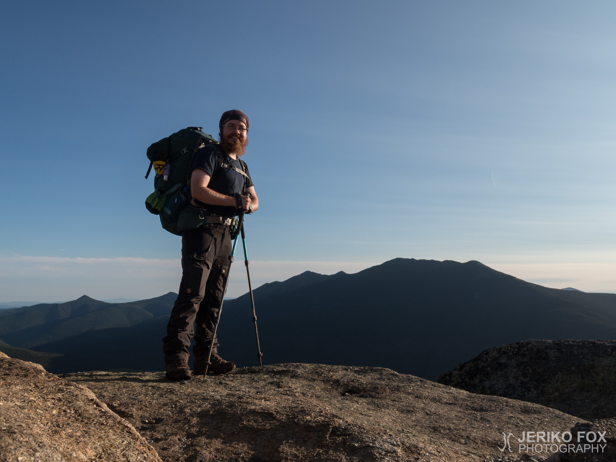
16,43 km (10.2 miles)
1827.2 / 2189.8 miles
Stealth campsite, NH

In the White Mountains there are two sections where one would wish for a good weather: Franconia Ridge and Mount Washington. Both are of course more scenic on a sunny day, but both can be dangerous on a bad weather.

My wish was about to come true considering Franconia Ridge. When I woke up in the morning after a restless night, the mountains were covered with clouds, but the weather forecast was showing clear skies for the afternoon. I took a shuttle with few other hikers from The Notch Hostel back to the AT and started the long uphill.

I was sitting on a rock having a break when a day hiker passed me. The man stopped to ask if I was a thru-hiker. He told me that he would like to do some trail magic, but he didn’t have any food with him. To my big surprise he then dug out his wallet and handed me a $20 bill. Astonished I thanked the man and decided to use the money for food – in the spirit of trail magic.

After ascending more than 1000 vertical meters (3300 ft) I reached the first summit of the day, Little Haystack Mountain. From there started the Franconia Ridge that traversed over the Mount Lincoln and Mount Lafayette above the treeline. The clouds were gone and the views on the ridge were great. The AT follows the ups and downs of the ridge and climbs to the more than 1600 m (5200 ft) high summit of Mount Lafayette.

When the ridge offered some cover from the wind the weather felt actually quite hot, but mostly there was a strong wind. The views were quite certainly the most astounding on the AT and I got to enjoy the beautiful scenery the whole traverse. It reminded me of my many great experiences on ridge climbing in the Alps: the summit ridge of Grossglockner, the Watzmann traverse, climbing to Hoher Göll and especially traversing the Jubiläumsgrat. The Franconia Ridge was not technically difficult like these ones, but still a scenic ridge anyway.

Arriving to the summit of Mount Lafayette I met my friend Mojo. We spent a while together until he started to descend and stayed to have my lunch break on the summit.

Mojo had told me that he was heading to the shelter that was on the north side of Mount Garfield. My initial goal was to reach a pond that was on the south side of the mountain, but I was thinking that if I had enough time I could go over the mountain, too.

While I was descending from the Mount Lafayette two women wearing day hiking gear passed me. In my mind I was wondering where they were going, because as far as I knew there was really nothing ahead of us. Considerably later I reached these women when they were just about to turn back after reaching two thru-hikers. These men told me that the women were heading to Mount Lafayette and had ended up going the wrong direction. We were thinking that they had no possibility whatsoever to get down from the mountain before dark. And we didn’t know if they had a head torch with them. It was likely that they had cell phones anyway. When I went on I couldn’t stop thinking that I should have asked their plans already when we first met. Or I could have offered them my head torch and ask them to mail it back to me to Gorham. I could have done without it for a while. Why all the good ideas always come too late? I hope that these women literally got out of the woods safely.

I reached the Garfield Pond before six and decided to throw myself over the Garfield Mountain. It was only 250 vertical meters (820 ft) of climbing, but the both sides of the hill were steep. Now the uphills have once again started to go better, so while listening to the Tuntematon Sotilas (The Unknown Soldier by Väinö Linna) I kept on hauling myself up. From the summit of Mount Garfield there was a breathtaking view to the Franconia Ridge. It felt quite unbelievable that I had walked that distance in one day. All the formations of the terrain was somehow setting to the right scale as I could clearly see my route.

I passed the north side shelter while I was going downhill. I could have stayed there, but I rather wanted to have the downhill done and find my own tent spot. Many of the shelters and campsites on the White Mountains have a fee. And the problem is not the €10 fee, but I preferred to have some peace and quiet.

The downhill was very rocky and steep. And the AT was going along a small stream. Or the other way around – depends how you want to see it. Anyway the water made the rocks slippery and I had to descend very carefully. On the bottom there was a flat section where I had planned to look for a tent spot. I was able to find one just where I had thought. I was happy with my achievements of today even though my feet were sore after the long descent. For the first time in a long while I put on a long sleeve shirt for the night, because it was getting a bit chilly. I had been sleeping in long johns and thicker socks already for a while now. When the darkness fell it was easy to answer the sweet call of my warm sleeping bag.

Total time: 03:07:01

White Mountainsilla on kaksi kohdetta, jonne erityisesti toivoisi hyvää säätä: Franconia Ridge ja Mount Washington. Molemmat ovat tietysti maisemallisempia aurinkoisena päivänä, mutta molemmat voivat olla vaarallisia paikkoja huonolla säällä.

Toiveeni näytti toteutuvan Franconia Ridgen osalta. Herätessäni levottomasti nukutun yön jälkeen olivat vuoret aamulla pilvessä, mutta sääennuste lupasi selkenevää. Matkustin muutaman muun vaeltajan kanssa The Notch Hostellilta aamun shuttle-kyydillä takaisin AT:lle ja lähdin nousemaan pitkää ylämäkeä.

Istuessani kivellä pitämässä pientä taukoa käveli ohitseni päivävaeltaja. Mies pysähtyi kohdalleni ja kysyi olinko läpivaeltamassa. Hän sanoi haluavansa tehdä trail magicia, mutta hänellä ei ollut ruokaa tarjota. Niinpä hän suureksi yllätyksekseni kaivoi esiin lompakkonsa ja lykkäsi käteeni $20 setelin. Ihmeissäni kiitin miestä ja päätin käyttää rahan trail magicin hengessä ruokaan.

Noustuani reilut 1000 m vertikaalia tulin päivän ensinmäiselle huipulle, Little Haystack Mountainille. Sieltä alkoi puurajan yläpuolella kulkeva Franconia Ridge Mount Lincolnin yli Mount Lafayettelle. Aamun pilvet olivat väistyneet ja näkyvyys harjanteella oli hyvä. AT kulkee harjanteen muotoja noudattaen ylös ja alas, päätyen reilun 1600 m korkeuteen Mount Lafayetten huipulla.

Suojaisissa paikoissa oli jopa kuuma, mutta muuten harjanteella puhalsi voimakas tuuli. Näköalat olivat varmasti näyttävimmät tähän mennessä koko AT:lla ja niitä sai ihailla koko harjanteen poikkikulun ajan. Mieleeni muistui monta hienoa harjannekiipeilykokemusta alpeilla: Grossglocknerin huippuharjanne, Watzmannin poikkikulku, Hoher Göllin nousu ja ennen kaikkea Jubiläumsgratin kiipeäminen. Franconia Ridge ei toki ollut näiden tapaan kiipeilyllisesti haastava, mutta näyttävä harjanne se on silti.

Saapuessani Mount Lafayetten huipulle tapasin ystäväni Mojon. Vietimme hetken aikaa yhdessä huipulla, kunnes hän lähti laskeutumaan minun jäädessä vielä pitämään lounastaukoa.

Mojo oli sanonut aikovansa Mount Garfieldin pohjoispuolella olevalle shelterille. Oma alkuperäinen tavoitteeni oli mennä vähintään kyseisen vuoren eteläpuolella olevalle lammelle, mutta ajattelin ehkä ajan salliessa mennä koko vuoren yli.

Laskeutuessani Mount Lafayettelta ohitseni kulki kaksi päivävaellusvarusteissa olevaa nuorta naista. Ihmettelin mielessäni heidän mentyä ohi, että minneköhän olivat suuntaamassa, kun edessä ei tietääkseni ollut niin sanotusti mitään. Huomattavasti myöhemmin saavutin naiset juuri kun he olivat kääntymässä kaksi muuta läpivaeltajaa tavattuaan takaisinpäin. Sain kuulla näiltä miehiltä naisten kai olleen matkalla Mount Lafayettelle ja menneen jossain väärään suuntaan. Mietimme yhdessä, että naiset eivät kyllä ehtisi alas vuorelta ennen pimeää mitenkään. Emmekä tienneet oliko heillä otsalamppujakaan. Kännykät toivottavasti olivat. Jatkaessani eteenpäin pyöri mielessäni, että olisi pitänyt tiedustella naisten päämäärää jo ensikohtaamisella tai toisaalta olisin voinut lainata heille otsalampun ja pyytää postittamaan sen Gorhamiin. Itse pärjäisin sen aikaa ilmankin. Miksi hyvät ideat tulevat aina myöhässä? Toivottavasti nämä naiset löysivät turvallisesti perille.

Tulin Garfield Pondille ennen kuutta ja päätin heittää itseni vielä Mount Garfieldin yli. Nousua oli vain noin 250 m vertikaalia, mutta rinne oli jyrkkä molemmin puolin. Ylämäet ovat kuitenkin alkaneet sujua, joten Tuntematonta sotilasta kuunnellen tahkosin ylös päin. Mount Garfieldin laelta avautui upea näkymä Franconia Ridgelle. Tuntui aivan uskomattomalta, että olin kulkenut koko näkemäni matkan yhdessä päivässä. Maaston muodot asettuivat jotenkin oikeaan skaalaan, kun näki selkeästi oman reittinsä.

Laskeutuessani kuljin pohjoispuolella olevan shelterin ohi. Olisin toki voinut jäädä sinnekin yöksi, mutta halusin mielummin saada alamäen tehdyksi ja etsiä oman telttapaikan. Monet White Mountainsin sheltereistä ja teltta-alueista ovat maksullisia. Ongelma ei niinkään ollut se, ettenkö olisi voinut yöpymisestä maksaa sen $10, mutta halusin olla omassa rauhassa.

Alamäki olikin todella jyrkkää kivikkoa ja osittain AT kulki pientä puroa pitkin. Tai toisinpäin – miten sen nyt haluaa ajatella. Joka tapauksessa vesi teki kivet liukkaiksi ja yritin laskeutua varovaisesti. Päästyäni alamäen loppuun tulin hieman tasaisemmalle alueelle, josta olin ajatellut etsiä telttapaikkaa. Löysinkin aivan mainion paikan juuri suunnittelemastani kohtaa. Päivän saavutukset tuntuivat hyvältä vaikka jalkaterät olivat hellänä pitkän laskeutumisrupeaman jäljiltä. Puin ensimmäistä kertaa pitkästä aikaa yöksi päälle pitkähihaisen paidan, koska ilta oli selvästi viileä. Pitkät kalsarit ja paksut sukat olin ottanut jo jonkin aikaa sitten yökäyttöön. Pimeän tullen lämpimän makuupussin lempeään kutsuun oli helppo vastata.

Day 166: North Woodstock

10,64 km (6.6 miles)
1816.7 / 2189.8 miles
The Notch Hostel, North Woodstock, NH

I saw the north summit of Kinsman Mountain that was one kilometre (0,6 mi) away when I was taking down my tent. A few minutes later, when the tent was packed, the summit was no longer there. The weather forecast was showing possible thunderstorms in the afternoon and I wanted to get down from the mountain before that.

When I arrived to the north summit the clouds had disappeared. While standing there and enjoying the view the cloud reappeared rising along the hillside and sucked me in within seconds. I continued down. The northern side of the mountain was steep and rocky like the south side that I had ascended yesterday. I was moving slowly, trying to inch myself down while looking for things to step on and not to slide down.

At the Lonesome Lake Hut I was pondering if I should peek inside this first AMC hut (there are several within the White Mountains). I decided to continue without stopping, but I didn’t get pass the hut when I heard someone shouting behind me: ”Finnisher!” AT-AT Walker had seen me passing by and told that the hut was serving free pancakes. There are many things in life that you can say no to, but free pancakes are not one of them. So, I went inside and learned that the hut croo was giving away the leftovers of breakfast: pancakes, eggs and oatmeal.

A weekend hiker was watching me with a disapproving look on his face while I was stuffing my face with few pancakes using my hands. I didn’t have the patience to sit down for any longer, because I needed to be in Franconia Notch by 3 pm to catch the shuttle ride. The downhill had taken a lot of time and I was only wishing that the AT was easier from here on.

Luckily my wish was granted and I marched on with the new energy given by the pancakes. AT-AT Walker caught me near the Franconia Notch and we were hiking together from the AT to the parking lot along a side trail. Serena, the owner of the Notch Hostel, picked us up perfectly on schedule and took us to the hostel in North Woodstock.

My hostel choice was a good one. The Notch Hostel is very clean and the $30 fee includes a bunk, laundry, ride to grocery store and pick up and return to the AT. Serena told us that tonight a local bar had a taco Tuesday and they offered a free shuttle there. Once again I got all my needs filled and my stomach, too. The thunder started to rumble after dark and the weather forecast for tomorrow seemed getting better. Those were very welcome news, because I was heading to the Franconia Ridge. On a good weather it would be one of the most scenic passages of the AT, but on the bad weather it can be a dangerous ridge.

Total time: 21:15:36

Näin kilometrin päässä olevan Kinsmanin pohjoishuipun ryhtyessäni purkamaan telttaani. Muutaman minuutin päästä, saatuani teltan pussiinsa, huippua ei enää näkynyt. Sääennusteessa oli ukkosmyrskyn mahdollisuus puolesta päivästä eteenpäin ja halusin päästä sitä ennen alas vuorelta.

Pohjoishuipulle saapuessani pilvet olivat taas hetkeksi väistyneet. Seistessäni katselemassa maisemaa pilvi kuitenkin nousi sekunneissa pitkin vuoren rinnettä imaisten minut sisäänsä. Jatkoin matkaa alas. Pohjoisen puoleinen rinne oli eilen nousemani etelärinteen tapaan kivikkoinen ja jyrkkä. Eteneminen oli hidasta hivuttautuessani alas sopivia askelmia etsien ja varoessani liukastumasta.

Tullessani Lonesome Lake Hutille mietin kävisinkö kurkkaamassa tämän ensimmäisen AMC:n ylläpitämän majan sisälle (näitä majoja on siis useampi White Mountainsin alueella). Päätin jatkaa pysähtymättä, mutta en päässyt kuin majan nurkalle asti, kun joku huusi takaani: “Finnisher!” AT-AT Walker oli nähnyt minut kulkemassa ohi ja huusi, että majalla olisi ilmaisia pannukakkuja. Kaikesta voi elämässä kieltäytyä, mutta ei sentään ilmaisista pannukakuista. Menin siis sisälle ja selvisi, että majan henkilökunta, croo, tarjoili ilmaiseksi aamupalan jämiä: pannukakkuja, munia ja puuroa.

Viikonloppuvaeltajan katsellessa vierestä paheksuva ilme kasvoillaan söin käsin muutaman pannukakun pahimpaan nälkääni. Sen pidempään en malttanut istua paikoillani, koska minun täytyi ehtiä kolmeen mennessä Franconia Notchiin shuttle-kyytiä varten. Alamäen alkuosaan oli tuhrautunut paljon aikaa ja saatoin vain toivoa AT:n olevan hieman helpompi majalta eteenpäin.

Tämä toiveeni onneksi toteutui ja marssin vauhdikkaasti alamäkeen pannukakkujen tuomalla uudella energialla. AT-AT Walker saavutti minut lähellä Franconia Notchia ja kuljimme yhtä matkaa AT:ltä erkanevaa sivupolkua kohti parkkipaikkaa. The Notch Hostellin omistaja Serena poimi meidät kyytiinsä sovittuna aikana ja ajelimme North Woodstockissa sijaitsevalle hostellille.

Yöpaikka osoittautui hyväksi valinnaksi. Hostelli oli hyvin siisti ja $30 hintaan sisältyi punkan lisäksi pyykinpesu, kyyti ruokakauppaan sekä hostellille ja takaisin AT:lle. Serena kertoi tänään paikallisessa baarissa olevan myös Taco-tiistai, jonne pääsisi illalliselle ilmaisella kyydillä. Näin ollen sain taas kerran pakolliset kuviot suoritettua ja vatsani täyteen. Ukkonen alkoi jyrähdellä vasta illan pimennyttyä ja huomisen sääennuste näytti myös muuttuneen parempaan suuntaan. Se tuli tarpeeseen, koska edessä oleva Franconia Ridge olisi hyvällä säällä yksi AT:n hienoimmista paikoista, mutta huonolla säällä vaarallinen harjanne.

Day 165: Kinsman Mountain

13,42 km (8.3 miles)
1810.7 / 2189.8 miles
Stealth campsite, NH

The Franconia Notch – next road crossing – was about 16 miles from me. Last night I had been thinking doing this section in one day, because it didn’t seem wise to split it to two days. Luckily I ended up sleeping in, because the day was about to prove me that I must have been temporarily insane considering a 16-mile day in the White Mountains.

I woke up at 8 am and realised that trying to reach the Franconia Notch today was unreasonable. Especially when the possible shuttle rides to town were scheduled to the afternoon. I decided to split the distance to ten and six miles.

My plan sounded like two easy days, but the reality was something completely else. Even though the morning didn’t offer any big climbs, my hiking was slow. The trail was often very narrow, rocky and root-covered maze in the dense forest. There was no flat sections whatsoever and I was constantly climbing and descending small and steep rock cliffs. In some places the AT was covered in mud. One mud puddle seemed too wide to go around, so I pushed my trekking pole in it to see how deep it was. Without any resistance the trekking pole sunk so deep that I didn’t dare to push it any further. I didn’t feel like stepping into a possibly bottomless mudpit. Luckily I was finally able to find a route around the puddle.

My feet were in pain and I was tired. Physically and mentally. And I was moving very slowly. While I was having a break on the Mount Wolf, a hiker that I met a few days ago, AT-AT Walker, passed me. This lovely professor of literature told me that she was planning to go to the next shelter and staying tomorrow at The Notch Hostel in North Woodstock. I told her that I was considering also staying at the same hostel, but trying to get past the next shelter today. Preferably over the Kinsman Mountain. AT-AT Walker continued her hike and I booked a bunk from the hostel now that I got some service on my phone.

I stopped at the Eliza Brook that was close to the shelter to eat and fill up my water. I was tempted by the AT-AT Walker’s idea of staying at the shelter, but I decided to stick to my plan and hike on.

I started to climb up the Kinsman Mountain. First the uphill was surprisingly easy, but quite quickly it changed steeper. Before too long I had to use my hands to ascend the rocky hill and it still seemed to get more steep. I wasn’t so sure anymore that I would reach the south summit before dark as I had planned.

As the trees were changing to stunted spruce and pines, the view behind my back was opening to the valley below. Sunset was painting its colours to the sky and I stopped to admire the view, until I had to continue my climb.

I reached the south summit of Kinsman Mountain just after the sunset. The sky was still in its colourful glory and all around me were standing the blue mountains that were forming the landscape. Small lights were lit down in the valley and soon they created a town. I enjoyed this beauty that was laid in front of me in that perfect solitude. While the wind was growing colder, I pulled my rain coat on and dug my head torch out of my backpack.

Close to the summit there was one tent spot, but in the White Mountains you are not really allowed to camp above the treeline (where trees are smaller the 2,5 m / 8 ft). My tent can take the high winds, but I decided to respect the rules and hiked on. I was wishing that in the saddle between the south and north summits there might be a tent site. Of course I knew that there was a possibility that I would have to descend the whole thing in dark. But I was more energetic than I had been in the morning, now that the colder weather had offered its refreshing effect.

Descending to the saddle I kept on looking for a tent spot from the forest around me. The forest was so dense, that there seemed to be nothing where one could fit a tent. After one kilometre (0,6 mi) I saw a perfectly flat and excellent spot for one tent right next to the trail. Feeling happy I lowered my backpack to the ground and started to put up my tent in a joyful mood. Even though my feet were aching, toes numb and the muscles of my thighs completely sore, I felt content. That euphoria that you get after a sports performance, even when in the beginning you don’t feel like doing it at all. For a long time I just sat in the doorway of my tent watching the stars appear to the sky and bathing in the perfect silence, until it was broken by a plane that flew above me.

Total time: 02:44:13

Franconia Notch eli seuraava tienristeys oli noin 16 mailin päässä. Olin edellisenä iltana miettinyt tämän pätkän menemistä yhdessä päivässä, koska sen jakaminen kahdelle päivälle ei tuntunut järkevältä. Onneksi kuitenkin nukuin aamulla pitkään, koska päivä tuli osoittamaan olleeni täydellisessä mielenhäiriössä kuvitellessani 16 mailin päivää White Mountainsilla.

Nousin siis kahdeksan aikoihin ja tulin siihen tulokseen, että Franconia Notchin tavoittamista ei kannattaisi yrittää. Etenkin kun potentiaalisten yöpaikkojen shuttle-kyydit sijoittuivat iltapäivään. Ajattelin jakavani matkan niin, että tekisin tänään noin 10 mailia ja huomenna loput.

Suunnitelma kuulosti kahdelta helpolta päivältä, mutta todellisuus oli toisenlainen. Vaikka aamupäivällä edessäni ei ollut suuria nousuja, vaeltaminen oli hidasta. Polku oli usein hyvin kapea, kivikkoinen ja juurien peittämä sokkelo tiiviin metsän sisällä. Tasaista ei ollut missään vaan nousin ja laskeuduin pieniä sekä usein jyrkkiä kallioita. Muutamassa paikassa AT oli mutalätäkön peitossa. Yhtä lätäkköä ei oikein voinut kiertää, joten kokeilin vaellussauvalla miten syvä se olisi. Sauva upposi vastuksetta niin syvälle, etten uskaltanut sitä enää syvemmälle työntää. En halunnut astua potentiaalisesti pohjattomaan mutahautaan. Onneksi löysin lopulta toisen reitin yli.

Jalat olivat kivuliaat ja olin väsynyt niin henkisesti kuin fyysisestikin. Ja liikuin todella hitaasti. Istuessani tauolla Mount Wolfilla käveli ohitseni muutama päivä sitten tapaamani AT-AT Walker. Tämä mukava kirjallisuuden professori kertoi aikoivansa seuraavalle shelterille ja huomenna North Woodstockiin The Notch Hostelliin. Mainitsin itsekin suunnitelleeni tekeväni huomiseksi varauksen samaan hostelliin, mutta aikoivani tänään hieman pidemmälle kuin shelterille. Mieluiten Kinsman Mountainin yli. AT-AT Walker jatkoi matkaansa ja minä jäin tekemään hostellivarausta saadessani kännykkään kenttää.

Pysähdyin shelterin tuntumassa olevalle Eliza Brookille syömään ja täyttämään vesivarastojani. Minua houkutteli hieman myös AT-AT Walkerin suunnitelma, mutta päätin kuitenkin jatkaa vielä eteenpäin.

Aloitin nousun kohti Kinsman Mountainia. Mäki oli aluksi jopa hetken helppokulkuista, mutta rinne muuttui nopeasti jyrkemmäksi. Hyvin pian sain käyttää käsiäni avuksi kiivetessäni kallioista mäkeä ylös ja jyrkkyys tuntui vain lisääntyvän. En ollut enää varma ehtisinkö ajatusteni mukaan vuoren etelähuipulle ennen pimeää.

Puiden muuttuessa pikkuhiljaa kitukasvuisiksi kuusiksi ja männyiksi alkoi selkäni takana avautua myös maisema alla olevaan laaksoon. Auringonlaskun maalatessa taivasta pysähdyin ihailemaan näköalaa, kunnes piti taas jatkaa kiipeämistä.

Saavutin Kinsman Mountainin etelähuipun hieman auringonlaskun jälkeen. Taivaalla oli vielä näyttävät värit ja sinisenä maisemaa muotoilevat vuoret seisoivat joka puolella. Valoja alkoi syttyä laaksoon ja pian ne muodostivat kaupungin. Nautin tästä eteeni tarjotusta kauneudesta ylhäisessä yksinäisyydessäni hetken. Tuulen alkaessa muuttua viileäksi vedin sadetakin päälleni ja kaivoin otsalampun repusta.

Huipun lähellä olisi ollut yksi telttapaikka, mutta White Mountainsilla ei oikeastaan saa telttailla puurajan yläpuolella (eli missä puut ovat alle 2,5 metrisiä). Telttani kestää kyllä hyvin kovaakin tuulta, mutta ajattelin kunnioittaa sääntöjä ja jatkoin eteenpäin. Elättelin toiveita, että etelähuipun ja pohjoishuipun välissä olevassa satulassa ehkä olisi joku telttapaikka. Tosin tiedostin, että saattaisin myös joutua laskeutumaan vuorelta alas asti. Olin kuitenkin piristinyt viilenneessä illassa, joten oloni oli energisempi kuin päivällä.

Laskeutuessani satulaan etsin aktiivisesti telttapaikkaa ympäröivästä metsästä. Puut kasvoivat kuitenkin niin tiiviisti, että teltan kokoista aukkoa ei tuntunut olevan. Kuitenkin noin kilometrin huipulta laskeuduttuani näin juuri yhden teltan kokoisen erinomaisen tasaisen paikan polun vieressä. Laskin onnellisena reppuni maahan ja ryhdyin iloisena iltatoimiin. Vaikka jalkaterät olivat arat, varpaat tunnottomat ja reisilihakset aivan hellänä, tunsin tyytyväisyyttä. Sitä euforiaa, joka iskee urheilusuorituksen jälkeen, vaikka aluksi ei olisi oikein edes huvittanut. Istuin pitkään telttani oviaukossa katsomassa ylleni syttyviä tähtiä ja nauttimassa täydellisestä hiljaisuudesta, kunnes sen lopulta rikkoi yli lentävä lentokone.