Orrainpolku

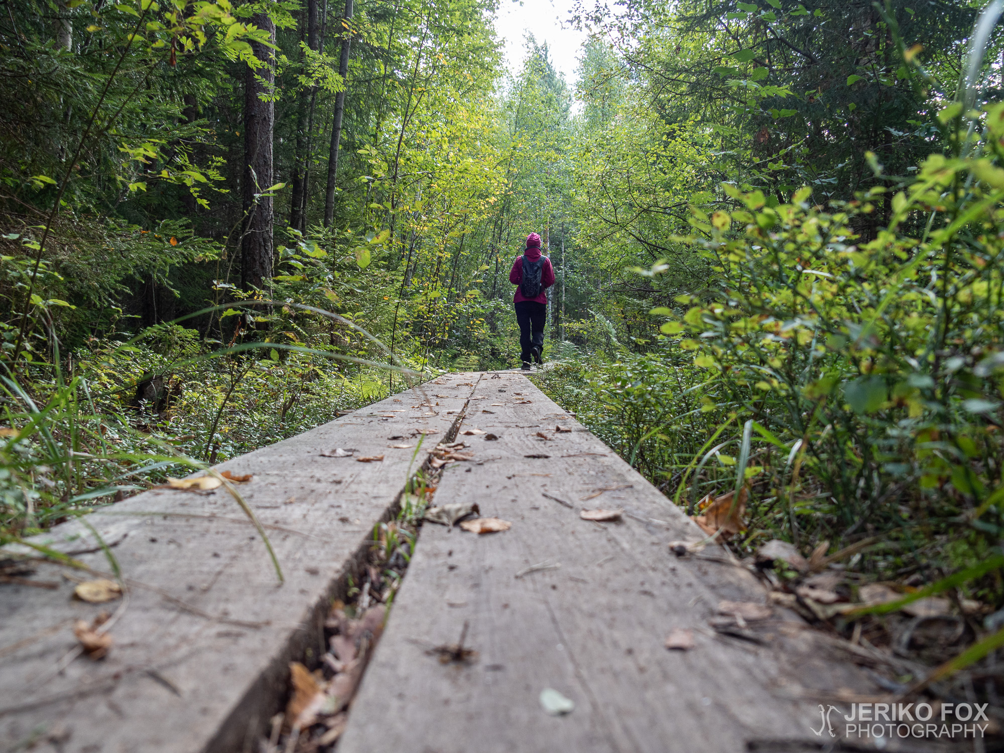
The Orrainpolku Trail in the village of Orrai in Savitaipale is one of the South Karelian classics. The trail is located near to Partakoski and is roughly 10 km (6.2 mi) long. Therefore its suitable either for a day hike or an overnight hike. There are two shelters along the trail, one of them pretty much in the midway. Both are sitting on a shore meaning there is also a chance to go swimming.

Me and Nina decided to hike the Orrainpolku in September, when it was still relatively warm. You find the trail head easily using Google Maps and there is a spacious parking lot as well. The first stretch is along a dirt road, but the trail soon turns into the woods. The trail is marked exceptionally well with signs and red dots on the trees. There is also a bike route and MTB track partially overlapping the trail and all of these are clearly indicated with images.

Terrain was pleasantly variable throughout the journey. On the open sections we got to enjoy the September sun and deeper in the woods of the magical atmosphere of a fairytale forest. The best landscapes were laid on our feet, when we hiked up the Luotolahdenvuori. From the cliffs there opened an amazing view over the Luotolahti of the Lake Kuolimo while we were surrounded by perfect silence.

Soon after we descended from the hill we arrived to the Luotolahti shelter. The lean-to is on a scenic spot on the shore of the Lake Kuolimo. It’s well maintained and has a privy, fire wood and a dock for canoeists and swimmers. We decided to have a lunch break and built a fire to fry some sausages, while some small birds were entertaining us by bustling around.

As we were passing the small pond called Ahvenlampi I saw something moving on the other shore. The white figure turned out to be a swan, which felt very surprising in the middle of the woods. I’ve mostly seen swans on more open areas and wetlands.

When there was only about a kilometre (less than a mile) left, we arrived to the Onkilampi shelter. We had only a short break there, but it’s worth mentioning that you can reach the lean-to also along the dirt road. That makes the shelter accessible, but getting all the way to the shore might be challenging if you are using a wheelchair or a walker.

The versatile terrain and landscapes as well as the properly maintained trail explain the classic status of the Orrainpolku. If you wish to add some other things to your bucket list on Savitaipale, the Kärnäkoski fortress is nearby and Partaranta restaurant is opening at Partakoski again next summer.

Orrainpolku 2021
Total time: 21:02:13

Orrainpolku Savitaipaleen Orrain kylällä on yksi ehdoton Etelä-Karjalan klassikkoreitti. Partakosken lähellä sijaitseva noin 10 km mittainen polku soveltuu niin päiväretkeksi kuin yön yli tehtäväksi reissuksikin. Orrainpolun varrella on kaksi laavua, joista toinen on suunnilleen puolivälissä matkaa. Molemmat ovat lisäksi rannalla, joten uintimahdollisuuskin on.

Kävimme Ninan kanssa vaeltamassa Orrainpolun syyskuussa, jolloin kelit olivat vielä lämpimät. Polun alkuun löytää helposti Google Mapsilla ja parkkipaikallakin on mukavasti tilaa. Alkumetrit kuljimme hiekkatietä, mutta hyvin pian käännytään varsinaisille metsäpoluille. Orrainpolku on merkitty todella hyvin kylteillä ja punaisilla täplillä puissa. Vaelluspolun lisäksi alueella kulkee pyöräily- sekä maastopyöräreitit, jotka on indikoitu selkein kuvin.

Maasto oli pitkin matkaa mukavan vaihtelevaa. Aukeammilla alueilla pääsi nauttimaan syysauringon paisteesta ja syvemmällä metsässä sammaleisen satumetsän tunnelmasta. Parhaimmillaan maisemat kuitenkin olivat, kun nousimme Luotolahdenvuorelle. Kalliolta avautui kaunis näköala Kuolimon Luotolahdelle, jota saattoi ihailla täydellisen hiljaisuuden ympäröimänä.

Pian mäeltä laskeuduttuamme saavuimme Luotolahden laavulle. Kuolimon rannalla oleva laavu on todella viihtyisällä paikalla ja lisäksi hyvin varusteltu – löytyy huussi, polttopuita ja laituri rantautumiseen tai uimiseen. Päätimme pitää laavulla evästauon ja paistoimme makkaraa pikkulintujen touhutessa ympärillä.

Ohittaessamme pientä Ahvenlampea näin jotain liikkuvan lammen toisella rannalla. Valkoinen hahmo osoittautui joutseneksi, joka tuntui hyvin yllättävältä näyltä näin metsän keskellä. Yleensä olen nähnyt niitä aukeammilla alueilla ja kosteikoissa.

Vain reilun kilometrin ennen reitin loppua saavuimme Onkilammen laavulle. Pysähdyimme tässä vain hetkeksi, mutta on mainitsemisen arvoista, että Onkilammelle pääsee myös hiekkatietä pitkin, joten laavu on esteettömästi saavutettavissa. Aivan rantaan asti voi kuitenkin olla vaikea mennä pyörätuolilla tai rollaattorilla.

Monipuoliset maisemat ja hyvin hoidettu reitti lunastavat kiistämättä Orrainpolun klassikkomaineen. Jos samaan retkeen haluaa yhdistää muita kohteita, on lähialueella esimerkiksi Kärnäkosen linnoitus ja Partakosken Partarantaan on aukeamassa seuraavaksi kesäksi taas ravintolatoimintaa.

Säänjärvi Trail

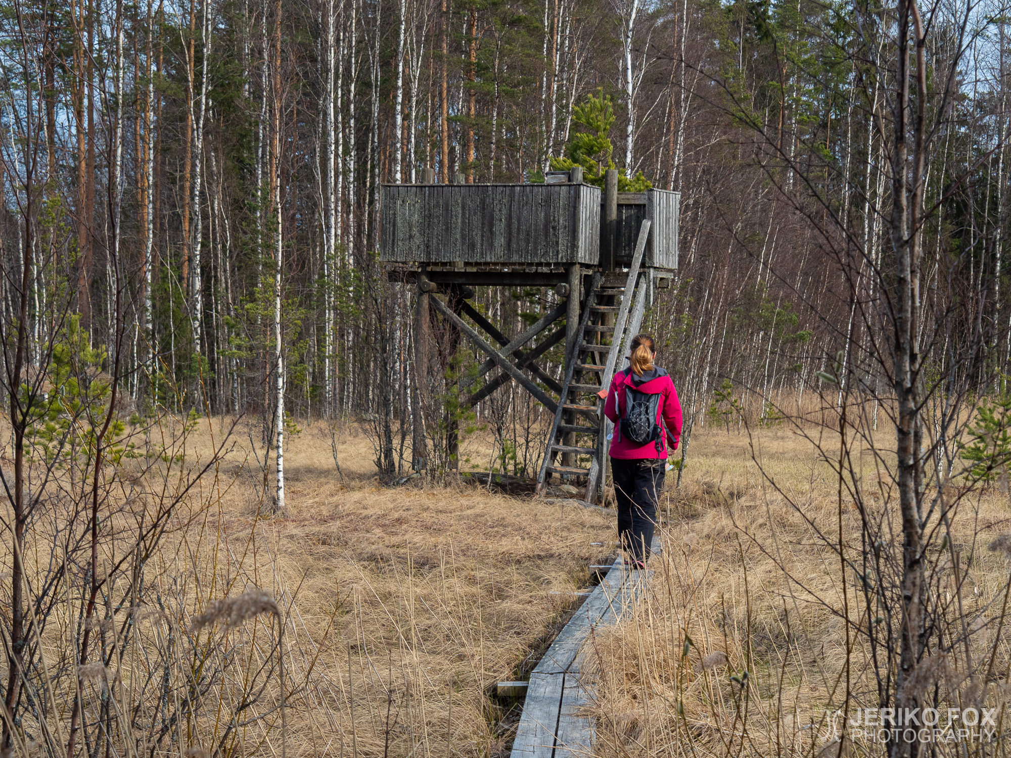
The village of Savitaipale is not very far from Lappeenranta and offers a lot of outdoor activities. I have made a MTB trip there near the Lake Kuolimo for example. A new discovery for me was the Säänjärvi Trail, which is delightingly versatile.

The trail starts from the old school of Säänjärvi village (Säänjärventie 401) – a private property nowadays. There is a designated parking space next to the trash bins. Close by is also an information board and a mail box where one can borrow a map and a guide leaflet about the sights along the trail. The trail itself is marked extremely well with signs and red diamonds.

The four kilometre (2.5 mi) trail follows a dirt road before it heads into the woods. Some of the sights on the trail are historical old buildings and some are nature sights. The trail goes around the Lake Valkjärvi and one of the most interesting sights is the bird hide in the wetlands near the lake. I’m not that much into bird watching, but these towers offer usually nice views.

After people locked themselves indoors after the coronavirus outbreak and then again most of the activities changed into outdoor ones, many got involved of a teddy bear challenge. The idea is to place a teddy bear into one’s window, so that children (and why not adults too) passing by can enjoy spotting them. Well, someone had brought the teddy bear challenge to the Säänjärvi Trail too by placing a small teddy bear into a barn’s door handle. With a note saying “bringing good mood”.

And good mood is what this trail has to offer. An ant nest that is more than one metre (more than 3 feet) high is a beautiful sight and even more fun is a climbing place at Piilukivet. Glacial erratics in the woods have stairs that you can use to climb on them, or if you wish more challenge you can use a rope instead.

Roughly in the halfway of the trail there is a goahti (and a privy), which is a good rest stop, but also for an overnight stay. In the end of the trail is a lean-to (and a privy) right next to the shore of the Lake Valkjärvi. Which naturally means also a swimming opportunity. If one wishes to make just a short walk in the woods or comes for a swim, one can take the route in the opposite direction, which makes it only about hundred meters (about hundred yards) from the parking lot to the lean-to.

The Säänjärvi Trail is a fun trip in an easy terrain and the trail is very well marked. All the sights and shelters along the trail makes it also inviting for families with children.

Total time: 18:20:35

Savitaipale on kohtuullisen matkan päässä Lappeenrannasta ja tarjoaa monenlaisia mukavia ulkoilumahdollisuuksia. Aiemmin olen käynyt siellä mm. maastopyöräilemässä Kuolimon järven ympäristössä. Uusi löytö itselleni alueelta oli Säänjärven retkeilyreitti, joka on monipuolisuudessaan ilahduttava.

Reitti alkaa Säänjärven entisen koulun pihasta (Säänjärventie 401), joka on nykyään yksityisomistuksessa, mutta roskakatoksen viereen on merkitty selkeä parkkipaikka retkeilijöille. Lähellä on ilmoitustaulu karttoineen ja postilaatikosta voi ottaa myös lainaksi kartan ja selostuksen polun varrella olevista rasteista. Reitti on merkitty todella selkeästi kylteillä ja punaisin neliöin.

Reilun neljän kilometrin reitti alkoi hiekkatietä pitkin. Osa rasteista oli historiallisia vanhoja rakennuksia ja osa luontokohteita. Polku kiertää Valkjärven ympäri ja yksi kiinnostavista paikoista olikin järven rannassa kosteikkoalueella oleva lintutorni. En itse ole erityisemmin perehtynyt lintujen bongailuun, mutta torneista on aina mukava näköala.

Ihmisten sulkeuduttua kohteihinsa koronaviruksen vuoksi ja toisaalta liikunta-aktiviteettien siirtyessä ulkoilmaan monet ovat innostuneet nalle-haasteesta, jossa ikkunaan laitetaan nalle. Näin kävelyllä olevat lapset (ja miksi ei aikuisetkin) saavat kivaa tekemistä, kun ikkunoista voi bongailla nalleja. No, joku oli tuonut nalle-haasteen myös Säänjärvelle ja asettanut pienen nallen erään ladon ovenkahvaan – mukanaan lappu “hyvän mielen asialla”.

Hyvän mielen yllätyksiä reitti tarjoaakin. Polun varrella oleva toista metriä korkea muurahaispesä on hieno nähtävyys ja sitäkin hauskempi on piilukiville tehty kiipeilypaikka. Metsässä olevien siirtolohkareiden päälle on rakennettu portaat ja enemmän haasteita haluavalle köyden avulla kiipeämismahdollisuus.

Reitin puolivälin paikkeilla on kota (ja huussi), joka on hyvä taukopaikka, mutta soveltuu myös yöpymiseen. Reitin loppupäässä on laavu (ja huussi) aivan Valkjärven rannassa. Tällä on myös mahdollisuus uimiseen. Lyhyemmälle retkelle tai vain uimaan tuleva voi lähteä reittiä päinvastaiseen suuntaan, jolloin parkkipaikalta ei tule kuin reilu sata metriä laavulle.

Säänjärven retkeilyreitti on hauska retki helpossa maastossa ja polku on erinomaisesti merkitty. Erilaiset rastit ja taukopaikat tekevät reitistä viihtyisän kohteen myös perheille.

Lake Kuolimo MTB Trail

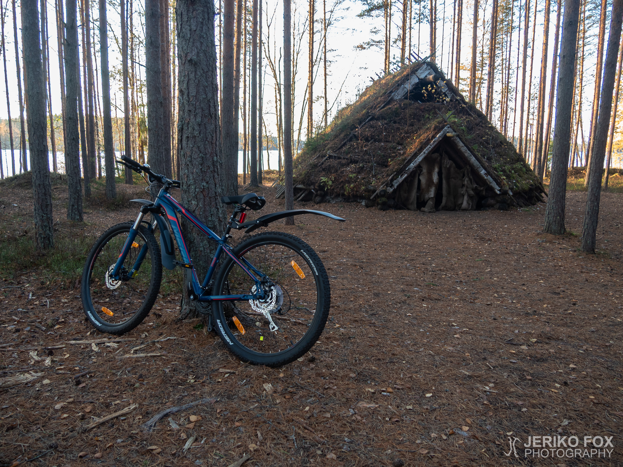
The best fall foliage was already gone, but the trees still were brightly yellow, when I was parking my car on an October afternoon to the Olkkola mansion by the Lake Kuolimo in Savitaipale. I lifted off my bike that was sprawling from the trunk and put my helmet on.

From Olkkola starts a trail system called Jääkauden jäljet – kivikauden ihminen (Traces of ice age – Stone Age human), which includes biking and hiking trails plus an art trail (more info in Finnish from eKarjala and Outdoors Finland). As the name indicates, these trails go through the terrain that is heavily affected by the ice age and there is also a reconstruction of a Stone Age home. The MTB trail is about 19 km (11,8 mi) and the hiking trails come in different lengths.

Right in the beginning I took a detour, because I wanted to ride the art trail. This route might not be actually for biking with its steep hills, but it truly was a hell of a ride! Along the art trail there are small sculptures made of natural materials. I had to look for a while to find my way back to the bike trail, but finally I got to the Uuhijoki mill and was back on the route.

The bike route followed a dirt road for a while and then turned back to the forest. Soon I saw a sign by the trail that recommended me to carry or lead my bike for the next 400 m (0.25 mi). That section was more of a bushwhack, but still rideable. Not too long after that I was once again on a dirt road that took me to the Lepänkanto recreation area. Close to the beach is a parking lot, which allows one to start hiking from there.

From Lepänkanto to Rovastinoja the route follows dirt and forest roads. Rovastinoja is an extremely beautiful spot by the Lake Kuolimo. There is a goahti-like peat hut that is a reconstruction of a Stone Age home, which would be a great place to stay a night. By the lakeside there is a fire pit and steps that lead into the lake. Not to mention the wood shed and a privy. I continued a bit further along the trail that ended right into someone’s backyard.

Rovastinoja is a very fine destination and I will definitely return there one day. This time I wasn’t prepared to stay any longer and I started to ride back towards Olkkola. The sun was already setting, so I wanted to get out of the forest before dark. On my way back I rode all the way along the bike route.

The Lake Kuolimo MTB trail is not technically demanding. During the summer both Lepänkanto and Rovastinoja are great places to have a break and to dive into the clear watered Lake Kuolimo. For those who are interested of the geomorphology of the area there are information signs along the trail. I ended up riding 23 km (14.3 mi), when I took the art trail also.

Total time: 18:43:50

Paras ruska oli ehtinyt jo mennä ohi, mutta puut hohtivat vielä keltaisena ajellessani lokakuisena iltapäivänä Kuolimon rannalla sijaitsevan Olkkolan hovin pihaan Savitaipaleella. Nostin takakontista retkottavan polkupyörän maahan ja köytin kypärän päähäni.

Olkkolasta alkaa Jääkauden jäljet – kivikauden ihminen -reitistö, joka koostuu vaellus- sekä maastopyöräilypoluista sekä taidepolusta (lisää tietoa eKarjala-portaalista ja Outdoors Finlandista). Nimensä mukaisesti reittien varrella on nähtävissä jääkauden muokkaamaa maastoa ja kivikautisen asumuksen rekonstruktio. Maastopyöräreitti on noin 19 km ja vaellusreittejä on eri mittaisia.

Tein heti alusta pienen ylimääräisen mutkan matkaan, kun päätin ajella taidepolkua pitkin. Tämä reitti ei ehkä ihan ensisijaisesti ole pyöräilyyn tarkoitettu jyrkkine mäkineen, mutta ainakin ajaminen oli hauskaa! Taidepolun varrella on erilaisia luonnonmateriaaleista tehtyjä patsaita. Jouduin hieman etsiskelemään taidepolulta pyöräreitille löytääkseni, mutta lopulta päädyin Uuhijoen myllylle, josta liityin oikealle reitille.

Reitti seurasi hetken hiekkatietä, josta käännyin taas metsään. Polulla tuli vastaan kyltti, jossa kehotettiin taluttamaan tai kantamaan pyörää seuraavat 400 metriä. Tuo pätkä oli ryteikköisempi, mutta kuitenkin ihan poljettavissa. Pian tämän jälkeen siirryin taas hiekkatielle, jota pitkin ajoin Lepänkannon virkistysalueelle asti. Uimarannan tuntumassa on parkkipaikka, joten vaellusretken voi aloittaa myös sieltä.

Lepänkannolta Rovastinojalle reitti jatkuu hiekka- ja metsäautoteitä pitkin. Rovastinoja on hyvin kaunis alue Kuolimon rannalla. Paikalle on tehty kivikautista asumusta jäljittelevä kotamainen turvemaja, jossa itseasiassa voisi varsin hyvin yöpyäkin. Rannassa on tulentekopaikka ja portaat järveen sekä myöskin puuliiteri ja huussi löytyy. Jatkoin vielä lyhyen matkaa polkua eteenpäin, kunnes se päättyi jonkun takapihalle.

Rovastinoja on erittäin hieno retkeilykohde ja tulen varmasti palaamaan vielä sinne. Tällä kertaa en ollut kuitenkaan varautunut jäämään pidemmäksi aikaa, vaan lähdin polkemaan takaisin kohti Olkkolaa. Aurinkokin alkoi jo laskea, joten halusin pois metsästä ennen pimeää. Paluumatkan kuljin kokonaan pyöräreittiä pitkin.

Kuolimon läheisyydessä kulkeva Jääkauden jäljet – kivikauden ihminen -maastopyöräreitti ei ole teknisesti vaativa. Kesäkaudella loistavia pysähdyspaikkoja ovat Lepänkanto ja Rovastinoja, joissa voi molemmissa pulahtaa uimaan kirkasvetiseen Kuolimoon. Alueen geomorfologiasta kiinnostuneille on tarjolla infotauluja reitin varrella. Pyöräilymatkaa minulle kertyi 23 km, kun kuljin myös taidepolun kautta.