
I woke up at 6 am, at the sunrise, and told Dima to wake up too. While the two men from Dresden were still sleeping, we packed our things and went outside to enjoy a refreshing breakfast in form of Corny bars. The morning sun started to shed its first rays of light over the surrounding mountains, but it was still quite chilly so I ended up wearing an insulating hoodie under my soft shell jacket. The weather was perfectly clear and it was obvious that the day would be fantastic.
We left the bivy at 06:30. This day was very different from yesterday, since our destination, Zugspitze, was clearly visible all day. But then again the daily routine wasn’t anything new: climbing up and down. From what I had red beforehand, I knew that there would be less via Ferrata cables, but I really didn’t notice the difference. There was still cables in most of the steeper and more dangerous parts.
At 07:30 we summited the Mittlere Höllentalspitze (2743 m / 8999 ft) and saw that the guys from Dresden had left the bivy. The temperature started to rise gradually and I took off the soft shell jacket to avoid excess perspiration. At 08:30, little before reaching the Innere Höllentalspitze, we came to a crossroads that offered an opportunity to descend to Knorrhütte via Brunntalgrat. The sign said that Zugspitze was 3,5 hours away, but we used more time. Before 9 am we reached the last summit before Zugspitze: Innere Höllentalspitze (2741 m / 8993 ft).
For some reason I had (erroneously) thought that from now on the ridge would be gradually gaining elevation. And how wrong I was! Well, the average profile of the ridge was gradually rising, but in every turn we kept on climbing up and down – like we had been doing all the time. We started to meet other people, who had left from Zugspitze at dawn, meaning they were climbing to “downhill”. We saw them spread looking like a small groups of ants on the rock walls ahead of us.
After nine our friends from Dresden passed us by and abseiled with a rope one longer steeper section. We found that part being climbable and decided not to use rope just yet. The sun was shining and it was getting warmer, but the shadier parts of the ridge were significantly cooler.
We had a quick lunch break after ten on a small flat summit with many other climbers. While climbing from bivy to Zugspitze I noticed that many small flat areas like this had a tiny stonewall built around it. These places would be ideal spots for an open air bivy with a some kind of shelter from wind.
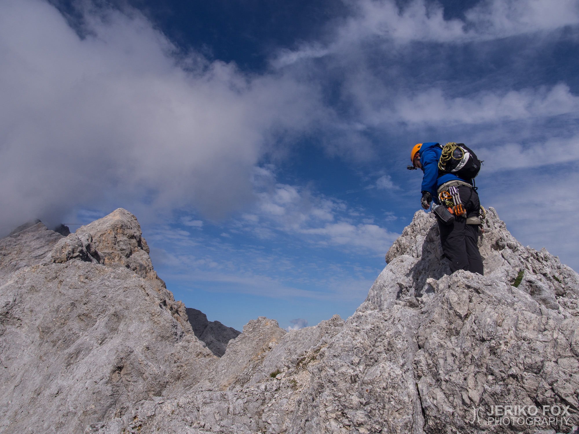
At noon we arrived to a cliff and Dima suggested that we could abseil with our rope. Terrain was climbable, but we thought that using the rope would be more safe and convenient. There was a metal ring bolted to the rock that we used as an anchor. We had a 30 m / 98 ft rope, because we didn’t think that we would need a longer one and didn’t want to carry any excess weight. The cliff was a little less than 15 m / 49 ft, so it was quite perfect for our rope. I somehow succeeded to pull my backup prusik insanely tight and because of that my abseiling was not the smooth one that I had planned, but an unsightly jerking down the rope.
Soon after our only rope action of this climb we found the crux of the day. The route was marked traversing over a 6 m / 20 ft high boulder that offered once again hanging over the void with moderate holds. I climbed over that rock, but Dima wanted to see if he could find a way around it. He did find an alternative route and we met each other on the other side of the rock.
For a while we had enjoyed the nice view down to Höllental, from where we climbed to Zugspitze two years ago. Little by little we also started to see the Höllentalferner-glacier in the end of the valley. The glacier seemed be more dry and had more crevasses open than in last few years. In addition there was a long line of ants…I mean climbers waiting for their turn to climb over the bergschrund and to proceed from the glacier to the rock. First time when I was climbing that route in 2012, this bottleneck had only a few people waiting. The second time, with Dima in 2013, there was approximately ten climbers. Now we could see far more than 50 climbers standing in line and the rock wall was also full of tiny dots moving with determination. I was utterly happy that I wasn’t climbing that “classic route” anymore. (On the very next day at the place I just described there was a climber without the appropriate gear. They got into some kind of trouble and a 24 years old man from Munich tried to help them – ending up himself falling into a crevasse and having life threatening injuries.)
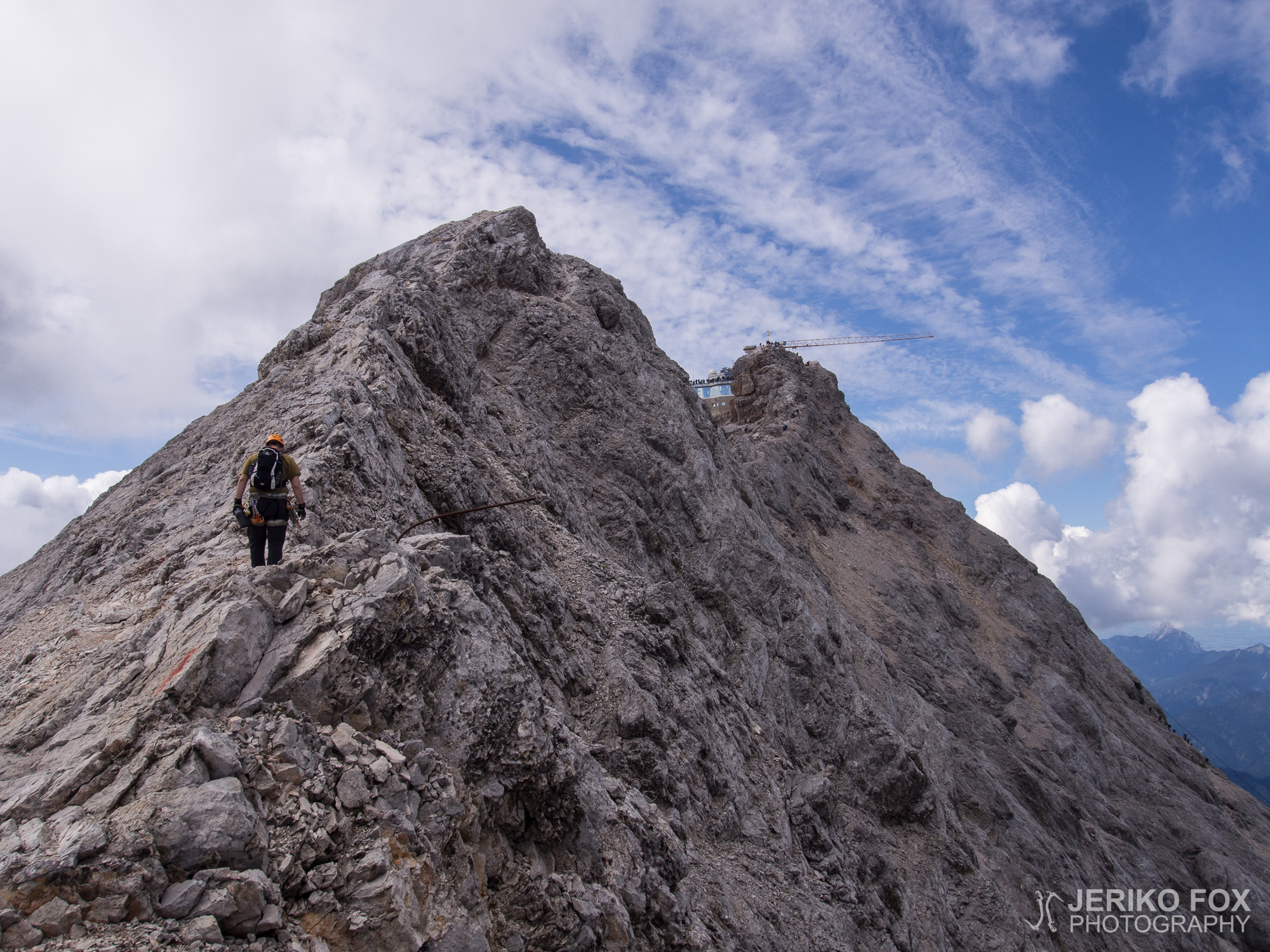
The day was turning to be a really hot one and I gave up one more layer of clothing, continuing to climb in a t-shirt. I recalled that I had forgotten to take the sunscreen with me and knew that I was going to burn my skin badly. From the last small summit before Zugspitze I called to my father, who had taken a cable car to Zugspitze. He told that he had already seen us and was taking photos from the terrace of Münchner Haus that is right next to the summit of Zugspitze.
The last section to Zugspitze was a plain trail, where we happened to find an ancient VF cable leading somewhere down to Schneeferner-glacier. We also passed the crossroads where climbers coming from Höllental ascend to Jubiläumsgrat and spent a little while talking with two climbers.
Like in every sunny day, the summit of Zugspitze was full of all kinds of couture-climbers with their handbags and flip flops. You can take a cable car right next to the summit and from the terrace there is a short scramble to the summit. After spending two days climbing the ridge, my tolerance to stand in line with this crowd to get my last summit wasn’t the best possible. Still, we played nice, waited in line and summited the top of Germany, Zugspitze (2962 m / 9718 ft), about at 14:30. For Dima it was the second time and for me the third. Reaching the summit didn’t feel very special, but finishing the Jubiläumsgrat was amazing.
Once again we had to stand in line to get away from the summit and to the terrace to meet my father. We went to have a soup lunch in the highest Biergarten of Germany and discussed about what to do next. Me and Dima had considered to descend to Reintal and walk all the way to Garmisch-Partenkirchen. That would mean many hours more to our already quite exhausting day. We decided to leave that for now and take the cog wheel train down to GaPa. My father was full of energy and he wanted to descend through that only hiking route of Zugspitze.
When my father disappeared marching vigorously down hill, me and Dima took the cable car to Schneeferner and continued with the cog wheel trail to GaPa. In that fully packed train happened something that I’ve witnessed countless times: all the people who had come up with the helping hand of the modern machinery rushed in to get to sit comfortably on a chair. The bunch of exhausted climbers had to sit on the floor and on the stairs in the doorway. Well, we found our own comfort after arriving to GaPa: me and Dima (for his request) headed straight to a Irish pub and guzzeled a pint of Guinness and Magners respectively.
After fulfilling my dream to climb the Jubiläumsgrat, I can agree with many climbing sites that this route is not (only) a via Ferrata, even though there are many cables. This misconception causes every year many ill-equipped and incompetent climbers to try the route. Accidents are often lethal, because there is nearly all the time several hundred meter (more than thousand feet) fall on your both sides.
Physically the route is demanding even for a fit climber. Unless you are one of those fast-and-light climbers, I recommend to split the route for two days like we did. To be able to start from the first cable car at Alpspitze and to reach the last cable car at Zugspitze one must be a VERY fast climber. With our skills Jubiläumsgrat can be climbed without a rope in summer – we used our rope only once to abseil. In summer I believe that the 30 m / 98 ft rope is sufficient – winter conditions might be a whole different game. VF device with shock absorber is a must, since there are sections that are secured with cables, but you still might fall several meters (more than 10 ft). Semi-rigid boots are a good choice and I think wearing helmet is mandatory when climbing outdoors. We took some slings and quickdraws for belaying, but no trad rack. We ended up using none of them, but I still would consider taking some gear that works as an anchor for belaying or as a running belay, if climbing simul.
We climbed, as we say in Finnish, slowly but securely. For example DAV says in the Münchner Haus’ website that climbing Jubiläumsgrat takes 11-13 h. We used 16 h in two days. The most fierce climbers are said to use only 8-10 h, but that means really climbing fast and not enjoying the views. In addition I think that our route, climbing “uphill”, takes more time than the classic way, climbing “downhill”. There are some anchors for abseiling, but these mostly serve going “downhill”. Meaning climbing from Zugspitze to Alpspitze it’s possible to save some time by using the rope.
Jubiläumsgrat is very straightforward ridge and finding the route is mainly easy – it’s practically impossible to get lost from the ridge. The challenge is just to find if you should climb over or around every summit and boulder. There are red route marks, but those are really worn out and the red lichen on the rock looks very similar.
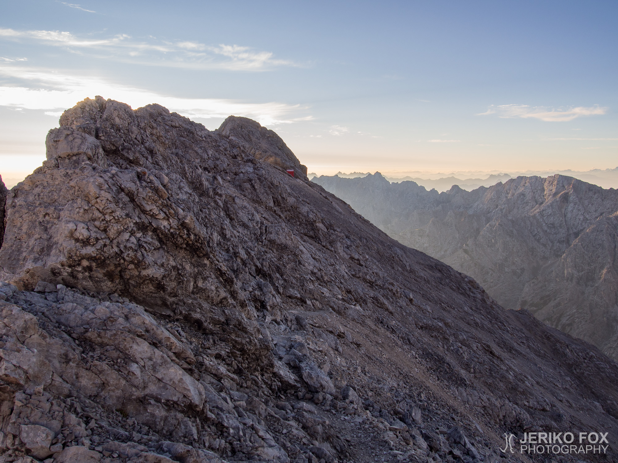
There are not many possible exits from the ridge once you got there, so you should pay close attention to the weather conditions and to your own resources before planning to climb Jubiläumsgrat. Between Alpspitze and Hochblassen there is one trail down to Grießkar and another to Matheisenkar. Next opportinity to exit is between Mittlere and Innere Höllentalspitze (closer to the latter) that takes you along the Brunntalgrat to Knorrhütte. Just before arriving to Zugspitze there is a chance to descend Höllental via Ferrata to Höllental, but I really wouldn’t use that as an emergency exit since Münchner Haus is behind the hill. In the eastern end of the ridge, near Alpspitze, there is no places for overnight quests in Osterfelderkopf. The closest place to offer a bunk is in Kreuzeck, that is little lower. In the middle of Jubiläumsgrat is Jubiläumsgratbiwak, where we stayed the night and in Zugspitze there is Münchner Haus. Prices for all the huts can be found from the DAV website and you must always make a reservation (except for the bivy). You must use a sleeping bag or at least a liner when sleeping in a hut or bivy for hygiene reasons. There is no water source at the bivy during the summer, so take enough of it with you (during the winter you can naturally melt the snow).
The best topo of Jubiläumsgrat can be found from Bergsteigen.com and you can download it as a PDF file. I recommend to take a map with you (I had Kompass Garmisch-Partenkirchen Mittenwald 1:35 000) and actually we were surprised to find out that the Jubiläumsgrat route is also drawn to the OpenStreetMap. There is a very good app called OsmAND (offline maps, too) for Android and iOS devices.


Heräsin aamulla kuudelta, auringonnousun aikaan, ja herätin myös Diman. Pakkasimme tavaramme Dresdeniläisten vielä nukkuessa ja menimme ulos nauttimaan aamupalaksi…mitäpä muutakaan kuin aina luotettavia Corny-patukoita. Aamuaurinko alkoi juuri valaista ympäröiviä vuoria, mutta ilma oli vielä senverran viileä, että puin softshellin alle lämpimän pitkähihaisen. Sää oli täysin kirkas ja päivästä näytti tulevan todella hieno.
Lähdimme liikkeelle noin puoli seitsemältä. Tämä päivä poikkesi merkittävästi edellisestä, koska päämäärämme, Zugspitze, oli koko päivän selkeästi näkyvissä. Mutta toisaalta ohjelma oli samaa kuin eilenkin: kiipeämistä ylös ja alas. Ennakkotietojen mukaan reitin jälkimmäisellä puoliskolla olisi huomattavasti vähemmän via Ferrata -vaijereita, mutta en erityisesti kiinnittänyt asiaan huomiota. Vaijereita oli kuitenkin melko kattavasti kaikissa jyrkemmissä ja selkeästi putoamisvaarallisimmissa paikoissa.
Ylitimme Mittlere Höllentalspitzen (2743 m) puoli kahdeksalta ja näimme samalla myös Dresdeniläisten lähteneen biviltä. Aurinko alkoi pikkuhiljaa lämmittää ja luovuin ensin softshell-takista välttääkseni tarpeetonta hikoilua. Puolen yhdeksän aikaan saavuimme hieman ennen Innere Höllentalspitzeä olevaan risteykseen, josta on mahdollista laskeutua Brunntalgratin suuntaan pois harjanteelta ja jatkaa Knorrhüttelle. Kyltti ennusteli noin 3,5 h matkaa Zugspitzelle, mutta me ylitimme sen arvion reilusti. Hieman ennen yhdeksää saavutimme viimeisen huipun ennen Zugspitzeä eli nousimme Innere Höllentalspitzen (2741 m) laelle.
Olin jotenkin erehtynyt ajattelemaan, että tästä eteenpäin harjanne olisi lähinnä tasaisesti nouseva. Arvatenkin olin väärässä, koska harjanteen keskimääräinen profiili nousi toki tasaisesti, mutta joka välissä kiivettiin taas tutuksi tulleeseen tapaan ylös ja alas. Aloimme myös pikkuhiljaa kohdata vastaantulijoita, jotka olivat lähteneet aamunkoitteessa Zugspitzeltä ja kiipesivät siis harjannetta “alamäkeen”. He levittäytyivät pienten muurahaisjonojen näköisesti edessämme oleville rinteille.
Yhdeksän jälkeen Dresdeniläiset ohittivat meidät ja laskeutuivat köydellä yhden pidemmän jyrkän pätkän. Tämä osio oli mielestämme kuitenkin ihan käytännöllisesti kiivettävissäkin, joten emme ottaneet vielä köyttä esiin. Aurinko paistoi jo melko kuumasti Jubiläumsgratille, mutta varjoisissa kohdissa oli selvästi kylmä.
Kymmenen jälkeen pidimme monen muun kiipeilijän tavoin pienellä tasanteella nopean evästauon. Bivistä Zugspitzellepäin kulkiessa huomasin monelle parin metrin tasanteelle rakennetun matalan kivimuurin. Näissä paikoissa pystyisi siis myös bivittämään kohtuullisesti tuulensuojassa tarvitsematta itse alkaa rakennuspuuhiin.
Saavuimme puolenpäivän aikaan jyrkänteen reunalle ja Dima ehdotti laskeutumista köydellä. Rinne olisi kyllä kiivettävissäkin, mutta totesimme köyden olevan tässä tapauksessa turvallinen valinta, kun tarjolla oli laskeutumiseen soveltuva kallioon pultattu rinkulakin. Mukanamme oli siis 30 m köysi, koska emme uskoneet pidempää tarvitsevamme emmekä halunneet kantaa turhaa painoa mukana. Jyrkänne oli juuri sopivasti hieman alle 15 m, jonka saatoimme siis kaksinkertaisella köydellä laskeutua. Onnistuin itse vetämään prusik-varmistukseni tarpeettoman tiukkaan ja jouduin sulavan laskeutumisen sijaan nylkyttämään itseni vähemmän esteettisesti köyttä alas.
Pian tämän laskeutumisen jälkeen tulimme toisen päivän kiipeilyllisesti haastavimpaan kohtaan. Reitti meni noin kuusimetrisen kivitöytäreen yli ja kohtalaisten otteiden varassa sai roikkua taas tyhjyyden yllä. Kiipesin reitin mukaisesti kiven yli, mutta Dima lähti katsomaan voisiko kiven kiertää sivukautta turvallisempaa reittiä. Hän löysikin jonkinlaisen vaihtoehtoisen reitin ja kohtasimme taas kiven toisella puolella.
Olimme jo aiemmin katselleet allamme avautuvaa näkymää Höllentaliin, josta olimme pari vuotta sitten itsekin kiivenneet Zugspitzelle. Aloimme pikkuhiljaa nähdä myös Höllentalin yläpäässä olevan Höllentalferner-jäätikön, joka näytti aikaisempia vuosia railottuneemmalta. Lisäksi jäätiköllä seisoi valtavan pitkä muurahaisjono…tai siis kiipeilijöitä odottamassa vuoroaan päästä ylittämään reunarailo ja siirtymään jäätiköltä kalliolle. Ensimmäisen kerran kiivetessäni tuota reittiä 2012, oli tässä pullonkaulapaikassa ehkä kourallinen ihmisiä. Toisella kertaa, kiivetessäni Diman kanssa vuonna 2013, jonossa oli noin kymmenen kiipeilijää. Nyt heitä seisoi jäätiköllä pitkälti yli viisikymmentä ja kalliokin oli täynnä pieniä määrätietoisesti eteneviä pilkkuja. Kiittelin onneani, etten ollut enää tuolla “perusreitillä”. (Seuraavana päivänä kyseisellä paikalla eräs ilman asianmukaisia kiipeilyvarusteita liikkeellä oleva henkilö oli joutunut jonkinlaisiin ongelmiin ja häntä auttamaan tullut 24-vuotias Müncheniläinen putosi railoon vammautuen hengenvaarallisesti.)
Aurinko porotti jo varsin kuumasti ja luovuin taas yhdestä vaatekerroksesta jatkaen kiipeilyä t-paidassa. Muistin kiivetessäni, että aurinkorasva oli jäänyt ottamatta mukaan ja tiesin jo odottaa palavani suorassa paahteessa. Viimeiseltä tasanteelta ennen Zugspitzea soitin isälleni, joka oli tullut meitä vastaan Zugspitzelle hissillä. Hän kertoikin jo huomanneensa meidät ja ottavansa valokuvia huipun viereiseltä Münchner Hausin terassilta käsin.
Viimeinen pätkä Zugspitzelle oli selkeää polkua, jonka varrelta löysimme myös sattumalta jonkun muinaisen via Ferrata -vaijerin. Sen irtonaiset pätkät johtivat jonnekin alas Schneeferner-jäätikön suuntaan. Ohitimme myös risteyskohdan, josta Höllentalin kiipelijät nousivat huipun luokse ja juttelimme hetken parin kiipeilijän kanssa.
Zugspitzen huippu oli kaikkien aurinkoisten päivien tapaan kaikenmaailman käsilaukkukiipeilijöiden valloittamana. Aivan huipun viereen pääsee siis hissillä ja terassilta voi kavuta lyhyen matkan itse huipulle. Kiivettyään kaksi päivää harjanteella oma sietokyky jonottaa huipulle pääsyä näiden hissituristien perässä on ehkä arvatenkin hieman huono. Seisoskelimme kuitenkin kiltisti jonossa ja nousimme (Dima toisen ja minä kolmannen kerran) Saksan korkeimmalle huipulle, Zugspitzelle (2962 m), noin puoli kolmelta. Itse huipun saavuttaminen ei tuntunut kovin erityiseltä, mutta Jubiläumsgratin selättäminen oli mahtavaa.
Jonotimme taas ihmismassan keskellä päästäksemme terassille isäni luokse. Menimme yhdessä syömään keitot ja keskustelimme jatkosuunnitelmista. Olimme Diman kanssa pohtineet laskeutuvamme Reintalin kautta jalkaisin Garmisch-Partenkircheniin, joka tarkoittaisi vielä monen monta lisätuntia raskaaseen päivään. Tulimme siihen tulokseen, että jättäisimme sen retken kuitenkin toiseen kertaan ja suuntaisimme hammasratasjunalla takaisin GaPaan. Isäni puolestaan oli tietenkin täysissä voimissaan ja hän päätti lähteä kulkemaan tuota Zugspitzen ainoaa vaellusreittiä alas.
Isäni kadotessa tarmokkaasti marssien alamäkeen, minä ja Dima ajoimme hissillä Schneefernerille ja jatkoimme sieltä junalla GaPaan asti. Täyteen ahdetussa junassa tapahtui aiemminkin todistamani ilmiö: konevoimalla huipulle nousseet turistit ryntäsivät istumaan mukavasti penkeille ja joukko väsyneitä kiipeilijöitä joutui istumaan junan eteisen lattialla. No, me keräsimme mukavuuspisteet suuntaamalla GaPaan saavuttuamme suoraan (Diman toiveesta) irlantilaiseen pubiin kaikkien kiipeilyvälineidemme kanssa ja kumosimme terassilla tyytyväisinä kurkkuumme tuopilliset Guinnessia ja Magnersia.
Kiivettyäni pitkään unelmoimani Jubiläumsgratin voin allekirjoittaa kaikkien kiipeilysivustojen toistaman mantran, ettei reitti ole (pelkkä) via Ferrata, vaikka vaijereita on paljon. Ja ymmärrän, että tämän harhaluulon takia Jubiläumsgratille päätyy vuosittain kiipeilijöitä liian vähällä kokemuksella ja huonoilla varusteilla. Onnettomuudet ovat usein kuolemaan johtavia, koska molemmille puolille on jatkuvasti satojen metrien pudotus.
Reitti on fyysisesti raskas hyväkuntoisellekin kiipeilijälle ja ellei satu olemaan hyvin nopea liikkuja vuorilla, suosittelen harkitsemaan puolittamaan työmäärän meidän tapaamme kahteen päivään. Ehtiäkseen Alpspitzen ensimmäiseltä hissiltä Zugspitzen viimeiselle hissille pitää olla TODELLA nopea kiipeilijä. Meidän tasollamme Jubiläumsgrat on kesäkaudella kiivettävissä ilman köyttä ja me käytimme köyttä siis vain yhteen (ei välttämättömään) laskeutumiseen. Kesällä uskon tuon 30 m köyden olevan sopiva mitta – talvikiipeily voi asettaa erilaisia vaatimuksia. VF-laite kannattaa ehdottomasti olla, koska Jubiläumsgratilla on mahdollista VF-vaijerein varmistetuissa paikoissa pudota useita metrejä. Puolijäykät kengät olivat hyvä valinta ja kypärä on mielestäni ulkona itsestäänselvyys. Meillä oli varmistamista varten mukana slingejä ja jatkoja, mutta ei varsinaista trädikamaa. Emme tosin käyttäneet näitä, mutta harkitsisin silti ottamaan jotain millä voi tarvittaessa kiinnittyä varmistamaan tai käyttää juoksevana varmistuksena kiivetessä simulina.
Kiipesimme reittiä sanonnan mukaisesti hitaasti, mutta varmasti. Esimerkiksi DAV arvioi Münchner Hausin sivuilla kiipeilyn kestoksi 11-13 h, me käytimme kahtena päivänä yhteensä noin 16 h. Hurjimmat arviot ovat olleet 8-10 h paikkeilla, mutta silloin täytyy jo oikeasti kiivetä todella kovaa vauhtia eikä paljon maisemia katsella. Lisäksi epäilen meidän tapaamme “ylämäkeen” kiipeämisen vievän hieman enemmän aikaa kuin tavallisen suunnan “alamäkeen”. Kallioon on asennettu jonkin verran laskeutumisankkureita, mutta nämä nimenomaan tukevat meille vastakkaiseen suuntaan kulkemista. Zugspitzeltä Alpspitzelle mennessä aikaa voi siis monessa paikassa säästää käyttämällä köyttä.
Jubiläumsgrat on suoraviivainen harjanne ja reitin löytäminen on siinä suhteessa helppoa – harjanteelta ei ole käytännössä mahdollista eksyä. Haasteet tulevat lähinnä siinä, että reittimerkit ovat kuluneita ja punaiset merkit sekoittuvat helposti samanväriseen kivien pinnassa olevaan jäkälään. Toisinaan joutuu siis katsomaan tarkasti onko suotavaa kiivetä jonkin kohouman yli vai kiertää se jommalta kummalta puolelta.
Poistumismahdollisuuksia harjanteelta on vähän, joten säähän ja omiin voimavaroihin kannattaa kiinnittää huomiota mielummin jo ennen kiipeämään lähtemistä. Alpspitzen ja Hochblassenin välistä menee polku Grießkariin ja Matheisenkariin. Mittelere ja Innere Höllentalspitzen välistä (lähempänä viimeksimainittua) menee Brunntalgratia pitkin polku Knorrhüttelle. Juuri ennen Zugspitzeä on myös mahdollisuus laskeutua Höllental via Ferrataa pitkin Höllentaliin, mutta sitä en suosittele hätäpoistumiseen, koska Münchner Haus on yhden mäen takana. Alpspitzen päässä Osterfelderkopfilla ei ole yöpymismahdollisuutta, mutta hieman alempana Kreuzeckillä voi yöpyä. Keskellä Jubiläumsgratia on Jubiläumsgratbiwak, jolla yövyimme ja Zugspitzellä on Münchner Haus, jossa voi myös yöpyä. Majakohtaiset hinnat löytyvät DAV:in sivuilta ja yöpaikka kannattaa aina varata etukäteen (biville ei voi tehdä varauksia). Majoilla ja bivillä edellytetään käytettävän hygieniasyistä omaa makuupussia tai vähintään makuupussin lakanaa. Bivillä ei ole juoksevaa vettä, joten kesällä nestettä kannattaa ottaa tarpeeksi mukaan (talvella voi tietysti sulattaa lunta).
Mielestäni ehdottomasti paras topo Jubiläumsgratista löytyy Bergsteigen.comin sivuilta ja sieltä sen voi ladata itselleen PDF-muodossa. Suosittelen ottamaan mukaan myös kartan (minulla oli Kompass Garmisch-Partenkirchen Mittenwald 1:35 000) ja itseasiassa yllätykseksemme huomasimme reittiä voivan tarkastella myös OpenStreetMapissa, josta löytyy hyvä sovellus OsmAND (myös offline-kartat) Androidille ja iOS-laitteille.
Max elevation: 2984 m
Total time: 08:10:08
[…] Previous Previous: Jubiläumsgrat: Day 2Next Next: Land of the Cheese […]
Hi Jeriko,
thank you for this nice blog. But I have to correct you in certain things. Most of the climbers are choosing the way “down” because of safety reasons. The most trickiest parts of Jubiläumsgrat are on the first half of the route (If you are going down), so it is more safe to go through it when your concentration is already high. There is also no big difference in the climbing time between going “up” or “down” – as you described the whole track is full of climbing up and down. If you are an experienced climber, you need about 8-10h to go this route “up” and about 7-9h to go “down” without using ropes at all. And you also have enough time to enjoy the landscape and taking pictues :-). The most important thing is that your weather is stable. It is also a pleasure to climb the Jubiläumsgrat in the winter!
Greetings,
GK