Rutola Village Trail

The Rutola village is located west from Lappeenranta – near the intersection of routes 6 and 13. In 19th century the village started to form near a log driving passage and a sawmill was built. Now one can dive into that history and experience the charming nature hiking the Rutola Village Trail, which starts from the Rutola volunteer fire department (VFD). As a bonus attraction the Salpalinja also runs though Rutola, hence there are bunkers along the trail.

On a sunny day of May me and Nina decided to check out the Rutola Village Trail. The trail is about 3 km (about 2 mi) and suits well for families with children also. Car can be parked at the VFD and there is also a route map on the wall.

Most of the buildings of the old sawmill are long gone, but ruins can be found throughout the trail. There are signs along the trail (much like on nature trails in general) that give more detailed information about the history and lives of the people.

The trail follows mainly dirt roads, but there are sections of forest trails, too. What it comes to the old sawmill, the most interesting sight might be the ruins of the sawmill itself. There are piles of moss covered rocks in a place where the sunlight gracefully falls though the spruce trees – a great photography location.

In Lapatonniemi the trail comes to the shore of the Lake Saimaa. There are boats of some locals, but I think nothing prevents one from dipping in though there is no official swimming place there.

On the way back the trail meets the Vanha Mikkelintie, where there are the Salpalinja bunkers. For these one should have a head torch (or actually it’s a good idea to have one always with you, though you wouldn’t plan for an overnight hike) because there is pitch black inside.

Already when we arrived to the trail I had paid attention of a gated area near the VFD and on our way back to the car we took a closer look. There is a huge cave – part of the Salpalinja – but gates and barbed wire fences are restricting the access. There are also warning signs in the area. (Jukka Siiskonen has written an interesting blog post in Finnish about the cave and there are photos, too.) I was of course excited about the cave, as usual, but getting there would need some special arrangements.

The Rutola Village Trail is a loop trail, hence it returns back to the VFD. Terrain is easy and the trail is well marked, so this is an excellent place for even beginner outdoor people.

Exceptionally this post won’t have a trail map, because my GPX recording app failed to create one. The trailhead can be found from here, though.

Rutolan kylä sijaitsee Lappeenrannan länsipuolella – 6- ja 13-teiden risteyksen tuntumassa. 1800-luvulla kylä muodostui tukinuittoväylän varteen ja sinne perustettiin saha. Nyt tähän historiaan ja alueen viehättäviin maisemiin pääsee tutustumaan Rutolan kyläpolulla, joka alkaa Rutolan VPK:n pihasta. Bonuksena Rutolan läpi kulkee myös Salpalinja, joten polulla on myös bunkkereita.

Aurinkoisena toukokuun päivänä lähdimme siis Ninan kanssa tutkimaan Rutolan kyläpolkua. Reitti on reilun kolmen kilometrin mittainen ja sopii hyvin myös perheille. Auton voi jättää VPK:n pihaan ja siellä on myös nähtävillä reittikartta.

Suurin osa vanhaan sahaan liittyvistä rakennuksista on tuhoutunut, mutta niiden raunioita löytyy pitkin metsää. Polun varrelle on pystytetty luontopolkujen tapaan kylttejä, jotka kertovat tarkemmin rakennuksista ja elämästä sahalla.

Reitti kulkee suurelta osin hiekkateitä pitkin, mutta kääntyy hetkittäin myös metsäpolulle. Kiinnostavin nähtävyys sahan osalta oli itse sahan rauniot, jotka sammaloituneina kiviröykkiöinä ovat myös varsin valokuvaukselliset valon siivilöityessä hienovaraisesti kuusikon läpi.

Polku tulee Saimaan rantaan Lapatonniemen kärjessä, jossa on paikallisten venepaikkoja. Mikään ei varmaan estäisi uimastakaan täällä, vaikka paikka ei virallinen uimaranta olekaan.

Paluumatkalla reitti tulee Vanhalle Mikkelintielle, jonka varressa sijaitsevat Salpalinjan bunkkerit. Näitä varten kannattaa olla otsalamppu mukana (ja muutenkin se on hyvä varuste pitää aina mukana, vaikka ei olisikaan menossa yön yli retkelle), jos haluaa mennä pimeisiin bunkkereihin.

Jo tullessamme olin kiinnittänyt huomiota VPK:n lähellä olevaan aidattuun alueeseen ja autolle palatessamme kävimme tutkimassa sitä tarkemmin. Kallioon on nimittäin louhittu Salpalinjaan kuuluva valtava miehistöluola, mutta pääsy sinne on estetty aidoin ja portein. Alueella on myös sortumisvaarasta varoittavia kylttejä. (Jukka Siiskonen on kirjoittanut luolasta kiinnostavan blogitekstin, jossa on myös kuvia luolasta.) Luolien ystävänä paikka tietenkin kiinnostaisi, mutta sinne pääsy vaatisi erityisjärjestelyjä.

Rutolan kyläpolku tekee luupin ja palaa siis takaisin VPK:lle. Maasto on helppoa ja reitti on hyvin merkitty, joten tämä on erinomainen kohde aloittelevallekin ulkoilijalle.

Poikkeuksellisesti tässä postauksessa ei ole reittikarttaa, koska GPX-tallentimeeni tuli jonkinlainen vika retken aikana. Reitin alku löytyy joka tapauksessa täältä.

Säänjärvi Trail

The village of Savitaipale is not very far from Lappeenranta and offers a lot of outdoor activities. I have made a MTB trip there near the Lake Kuolimo for example. A new discovery for me was the Säänjärvi Trail, which is delightingly versatile.

The trail starts from the old school of Säänjärvi village (Säänjärventie 401) – a private property nowadays. There is a designated parking space next to the trash bins. Close by is also an information board and a mail box where one can borrow a map and a guide leaflet about the sights along the trail. The trail itself is marked extremely well with signs and red diamonds.

The four kilometre (2.5 mi) trail follows a dirt road before it heads into the woods. Some of the sights on the trail are historical old buildings and some are nature sights. The trail goes around the Lake Valkjärvi and one of the most interesting sights is the bird hide in the wetlands near the lake. I’m not that much into bird watching, but these towers offer usually nice views.

After people locked themselves indoors after the coronavirus outbreak and then again most of the activities changed into outdoor ones, many got involved of a teddy bear challenge. The idea is to place a teddy bear into one’s window, so that children (and why not adults too) passing by can enjoy spotting them. Well, someone had brought the teddy bear challenge to the Säänjärvi Trail too by placing a small teddy bear into a barn’s door handle. With a note saying “bringing good mood”.

And good mood is what this trail has to offer. An ant nest that is more than one metre (more than 3 feet) high is a beautiful sight and even more fun is a climbing place at Piilukivet. Glacial erratics in the woods have stairs that you can use to climb on them, or if you wish more challenge you can use a rope instead.

Roughly in the halfway of the trail there is a goahti (and a privy), which is a good rest stop, but also for an overnight stay. In the end of the trail is a lean-to (and a privy) right next to the shore of the Lake Valkjärvi. Which naturally means also a swimming opportunity. If one wishes to make just a short walk in the woods or comes for a swim, one can take the route in the opposite direction, which makes it only about hundred meters (about hundred yards) from the parking lot to the lean-to.

The Säänjärvi Trail is a fun trip in an easy terrain and the trail is very well marked. All the sights and shelters along the trail makes it also inviting for families with children.

Total time: 18:20:35

Savitaipale on kohtuullisen matkan päässä Lappeenrannasta ja tarjoaa monenlaisia mukavia ulkoilumahdollisuuksia. Aiemmin olen käynyt siellä mm. maastopyöräilemässä Kuolimon järven ympäristössä. Uusi löytö itselleni alueelta oli Säänjärven retkeilyreitti, joka on monipuolisuudessaan ilahduttava.

Reitti alkaa Säänjärven entisen koulun pihasta (Säänjärventie 401), joka on nykyään yksityisomistuksessa, mutta roskakatoksen viereen on merkitty selkeä parkkipaikka retkeilijöille. Lähellä on ilmoitustaulu karttoineen ja postilaatikosta voi ottaa myös lainaksi kartan ja selostuksen polun varrella olevista rasteista. Reitti on merkitty todella selkeästi kylteillä ja punaisin neliöin.

Reilun neljän kilometrin reitti alkoi hiekkatietä pitkin. Osa rasteista oli historiallisia vanhoja rakennuksia ja osa luontokohteita. Polku kiertää Valkjärven ympäri ja yksi kiinnostavista paikoista olikin järven rannassa kosteikkoalueella oleva lintutorni. En itse ole erityisemmin perehtynyt lintujen bongailuun, mutta torneista on aina mukava näköala.

Ihmisten sulkeuduttua kohteihinsa koronaviruksen vuoksi ja toisaalta liikunta-aktiviteettien siirtyessä ulkoilmaan monet ovat innostuneet nalle-haasteesta, jossa ikkunaan laitetaan nalle. Näin kävelyllä olevat lapset (ja miksi ei aikuisetkin) saavat kivaa tekemistä, kun ikkunoista voi bongailla nalleja. No, joku oli tuonut nalle-haasteen myös Säänjärvelle ja asettanut pienen nallen erään ladon ovenkahvaan – mukanaan lappu “hyvän mielen asialla”.

Hyvän mielen yllätyksiä reitti tarjoaakin. Polun varrella oleva toista metriä korkea muurahaispesä on hieno nähtävyys ja sitäkin hauskempi on piilukiville tehty kiipeilypaikka. Metsässä olevien siirtolohkareiden päälle on rakennettu portaat ja enemmän haasteita haluavalle köyden avulla kiipeämismahdollisuus.

Reitin puolivälin paikkeilla on kota (ja huussi), joka on hyvä taukopaikka, mutta soveltuu myös yöpymiseen. Reitin loppupäässä on laavu (ja huussi) aivan Valkjärven rannassa. Tällä on myös mahdollisuus uimiseen. Lyhyemmälle retkelle tai vain uimaan tuleva voi lähteä reittiä päinvastaiseen suuntaan, jolloin parkkipaikalta ei tule kuin reilu sata metriä laavulle.

Säänjärven retkeilyreitti on hauska retki helpossa maastossa ja polku on erinomaisesti merkitty. Erilaiset rastit ja taukopaikat tekevät reitistä viihtyisän kohteen myös perheille.

Alajoki Trail

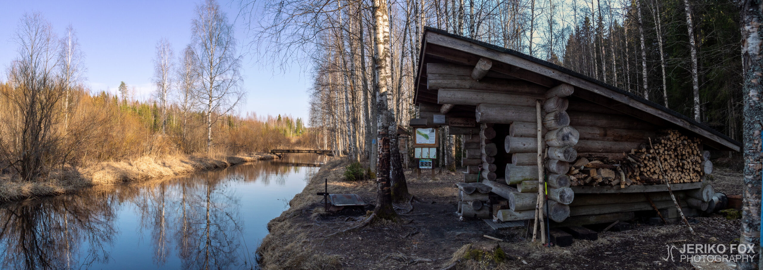
Couple of years ago I had been checking the Alajoki (lit. down river) canoeing route from the map, but wasn’t aware that along the river runs also a hiking trail. Now as I was searching for new less crowded hiking destinations, I happened to find the Alajoki Trail.

The corona virus pandemic started to affect Finland in the end of March and in April there was already significant restrictions set by the government. Outdoor activities in small groups were still allowed and this has made hiking more popular quite fast. In my personal life the dance teaching had gone to distance learning mode and hospital work also its own kind of state of emergency.

The south-east end of the Alajoki Trail is near Vainikkala and that is where you should approach the trail. There is not an actual parking lot at the trail head, but the narrow dirt road (Korpelantie) has a wider section where fits 2-3 cars and few more to the intersection nearby.

The route is marked with blue blazes and it’s very easy to follow. The terrain is variable, but not exceptionally difficult anywhere. Few sections of the trail are split to upper and lower routes – where the lower one is partially closed early in spring due flooding. The trail is 3 km (1.9 mi) one way and 6 km (3.7 mi) with return.

Before the halfway the trail leads up to a small hill from where there is a view over the wetlands and the railroad that leads to Russia. Despite of the pandemic there were trains passing by every now and then. There is also a bench where one can sit trainspotting.

At the halfway there is the Tuhkakangas lean-to, a wood shed and a privy. There is also a bridge crossing the river, but I didn’t really find out why. On the other side is not much more than the railroad.

From the lean-to we continued along the river. There had been one car at the parking lot and apparently the owner of the car was walking towards us on the trail. We talked with her for a while and agreed that this is a quite nice trail indeed. What makes it so good is the clarity (good trail signs), good maintenance (no bushwhacking) and versatility. There was flat sections and uphills and downhills and pine trees and wetlands and whatnot. I would call this one of the less known local gems.

As we arrived to the Kiekan mutka, the end of the trail, there was a field with a privy on its edge and a bridge across the river leading to a rest spot with a covered table. There is some trail going even further, but the official hiking route ends here. We had a short break and then started our return trip. Because the trail has partially these upper and lower alternatives, one can return with a slightly different route.

Total time: 18:45:29

Olin joskus pari vuotta aiemmin katsellut kartalta Alajoen melontareittiä, mutta en silloin ollut tietoinen, että joen vartta kulkee myös vaelluspolku. Nyt etsiessäni uusia vähemmän ruuhkaisia retkikohteita löysin sattumalta Alajoen retkeilyreitin.

Koronaviruspandemia alkoi vaikuttaa Suomessa maaliskuun lopulla ja huhtikuussa käytössä oli jo merkittäviä rajoitustoimia. Ulkoilua pienissä ryhmissä ei oltu kuitenkaan rajoitettu ja tämä onkin nostanut retkeilyn suosiota varsin nopeasti. Omassa elämässäni tanssinopetustyöt olivat siirtyneet etäaikaan ja sairaalatyöt taas omanlaisiinsa poikkeustoimiin.

Alajoen retkeilyreitin kaakkoispää on lähellä Vainikkalaa ja sieltä reittiä kannattanee lähestyä. Varsinaista parkkipaikkaa ei ole, mutta kapealla hiekkatiellä (Korpelantie) on pieni levennys, johon mahtuu 2-3 autoa ja viereiseen tienristeykseen pari lisää.

Reitti on merkitty sinisillä täplillä puuhun ja sitä on muutenkin helppo seurata. Maasto on vaihtelevaa, mutta ei erityisen vaikeakulkuista. Muutamassa kohdassa reitistä on valittavissa ylempi ja alempi – jälkimmäinen on osittain alkukeväästä suljettu tulvimisen takia. Yhteen suuntaan polku on 3 km eli edestakaisin kulkiessa matkaa tulee 6 km.

Ennen puoltaväliä reitti nousee pienelle mäelle, josta on näköala kosteikolle ja Venäjän puolelle vieville junaraiteille. Korona-ajasta huolimatta junia kulki retkemme aikana jonkin verran. Näköalapaikalla on myös penkki, jos haluaa rauhassa istua alas junabongailemaan.

Noin puolivälissä Tuhkakankaan laavu, jonka tuntumassa on myös puuvaja sekä huussi. Laavun läheltä Alajoen yli menee myös silta, mutta sen merkitys ei täysin avautunut minulle. Toisella puolella pääsee lähinnä junaradan luokse.

Laavulta jatkoimme pitkin jokirantaa. Parkkipaikalla oli ollut yksi auto tullessamme ja ilmeisesti tämän auton omistaja käveli nyt vastaamme. Juttelimme naisen kanssa hetken ja totesimme yhdessä, että tämä on kyllä erittäin mukava vaelluspolku. Miellyttävän reitistä tekee sen selkeys, siisteys (ei puskemista pusikoituneiden osioiden läpi) ja monipuolisuus. Välillä on tasaisempaa, välillä mäkisempää, hetkittäin ollaan havumetsässä ja toisinaan kosteikkoalueella. Sanoisinkin kyseessä olevan yksi paikallisista vähemmän tunnetuista helmistä.

Saapuessamme Kiekan mutkaan, reitin loppuun, tulimme ensin pellolle, jonka laidalla on huussi. Siltaa pitkin pääsee joen yli taukopaikalle, jossa on katettu pöytä. Polkua jatkuu tästä eteenpäinkin, mutta virallinen reitti päättyy tähän. Pidimme lyhyen evästauon ja lähdimme sitten palaamaan takaisinpäin. Koska reitillä on osittain ylempi ja alempi versio, voi halutessaan palata hieman eri polkua pitkin.

Mikonsaari Trail

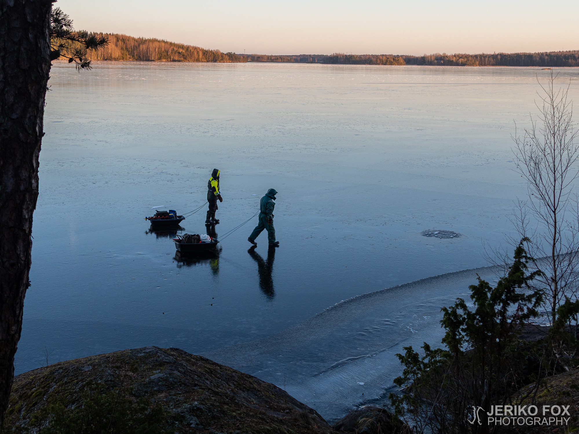
This year begun with gentle subzero weather and the snow was nowhere to be seen. The winter had been strange altogether and didn’t really have lots to offer for any winter sports. Though the upside is that hiking is easier, when you don’t have to go balls deep in snow.

I remember from my elementary school years that some of my friends had made school trips to Mikonsaari with their class. But for some reason I had never visited this small island near Lappeenranta. Even though it isn’t that far – about 10 km (about 6 mi) from the downtown. Hence Mikonsaari is a nice bike trip away from town – though we had a car this time.

The narrow road to Mikonsaari goes through Hyötiönsaari, Mustasaari and few other smaller islands, which makes it quite scenic. Soon after crossing the bridge to Mikonsaari, there is the parking lot of the nature trail on the right hand side.

Mikonsaari Nature Trail is about 2,5 km (1.5 mi), but there is also a shorter variation that is about 1,5 km (0.9 mi). Though the dusk was already creeping in, there were many families out and this route is actually a great choice for those with small children. The trail is marked with orange dots on trees and generally very easy to follow.

The trail passes the forest with massive spruces and then turns to a rocky shore, where is a fire pit at a scenic spot. On a thin looking ice was two guys ice fishing – defying the capacity of the ice in the usual carefree ice fisher demeanour.

At places the trail disappeared into the woods, but shortly returned back near the shore. From one hill there was a specially beautiful view over the lake Saimaa, when the afternoon dusk painted the landscape with vivid colours. At the end of the trail there is – also at a scenic location – a lean-to. Small one, but good enough for spending a night.

On the way back the spruce forest changed into a mixed one and soon into a deciduous forest. The trail followed a dirt road for a bit and then turned back into the woods at a spring. There is a well-like structure at the spring, but actually the water was clearer outside of it.

From the spring the trail leads back to the parking lot. The Mikonsaari nature trail is short, but a great choice for an easy hike. It seems to be popular for families and two fire pits at different parts of the trail should offer enough space for everyone to enjoy their snacks.

Total time: 17:19:26

Vuosi oli alkanut pienillä pakkasilla, vaikka lumesta oli tuskin tietoakaan. Kaikinpuolin kummallinen talvi ei erityisesti tarjonnut edellytyksiä talvilajeille, mutta toisaalta vähälumisuus mahdollisti vaeltamisen ilman lumessa kahlaamista.

Muistan jo joskus peruskoulussa kavereiden tehneen keväällä luokan kanssa retken Mikonsaareen, mutta en ollut itse tullut käyneeksi Lappeenrannan edustalla olevalla saarella koskaan. Vaikka matkaakaan ei ollut paljon – keskustasta noin kymmenisen kilometriä. Mikonsaari on siis mukavan pyöräilymatkan päässä, mutta me olimme tällä kertaa liikkeellä autolla.

Kapea tie Mikonsaareen kulkee Hyötiönsaaren, Mustasaarten ja muutaman muun pienemmän saaren kautta ja on siten varsin maisemallinen. Pian Mikonsaaren puolelle tultua on tien oikealla puolella luontopolun parkkipaikka.

Mikonsaaren luontopolku on noin 2,5 km pitkä, mutta siitä voi kulkea myös lyhyemmän variaation, joka on noin 1,5 km. Vaikka olimme liikkeellä jo iltapäivän hieman hämärtyessä, oli polulla jonkin verran perheitä ja reitti sopiikin hyvin myös pienten lasten kanssa kuljettavaksi. Luontopolku on merkattu oransseilla ympyröillä puuhun ja muutenkin helposti seurattavissa.

Reitti ohittaa jykevän kuusikon ja kaartaa kallioiselle rannalle, jossa on maisemallinen nuotiopaikka. Ohuen näköisellä jäällä oli myös kaksi pilkkijää, jotka lajin harrastajien tavanomaisella huolettomuudella uhmasivat jään kantokykyä.

Polku pistäytyi välillä metsäänkin, mutta seuraili pääasiassa rantaa. Yhdeltä kalliolta avautui kaunis näköala Saimaalle ja iltapäivän hämärä itseasiassa maalasi maiseman näyttävin värein. Polun päädyssä on myöskin maisemallisella paikalla laavu, joka on melko pieni, mutta siellä pystyy halutessaan yöpymään.

Paluumatkalla kuusikko muuttui sekametsäksi ja pian lehtipuuvoittoiseksi lehdoksi. Pienen pätkän reitti seurasi hiekkatietä, jolta kääntyi takaisin metsään lähteen kohdalla. Lähteelle on tehty kaivomainen rakennelma, mutta tällä hetkellä kirkkaampaa vettä olisi saanut oikeastaan sen ulkopuolelta.

Lähteeltä polku vie takaisin parkkipaikalle. Mikonsaaren luontopolku on lyhyt, mutta sopii hyvin kevyttä retkeilyä kaipaaville. Kohde vaikuttaa olevan perheiden suosiossa ja makkaranpaistoonkin tilaa riittää, kun tulentekopaikkoja on kaksi.